Posted on Leave a comment

Have Parks Victoria Really Banned Scrambling in the Grampians National Park?

Bushwalkers scrambling on the Stapylton Amphitheatre walk linking Hollow Mountain with Mt Stapylton. One of the most spectacular day walks in Victoria.

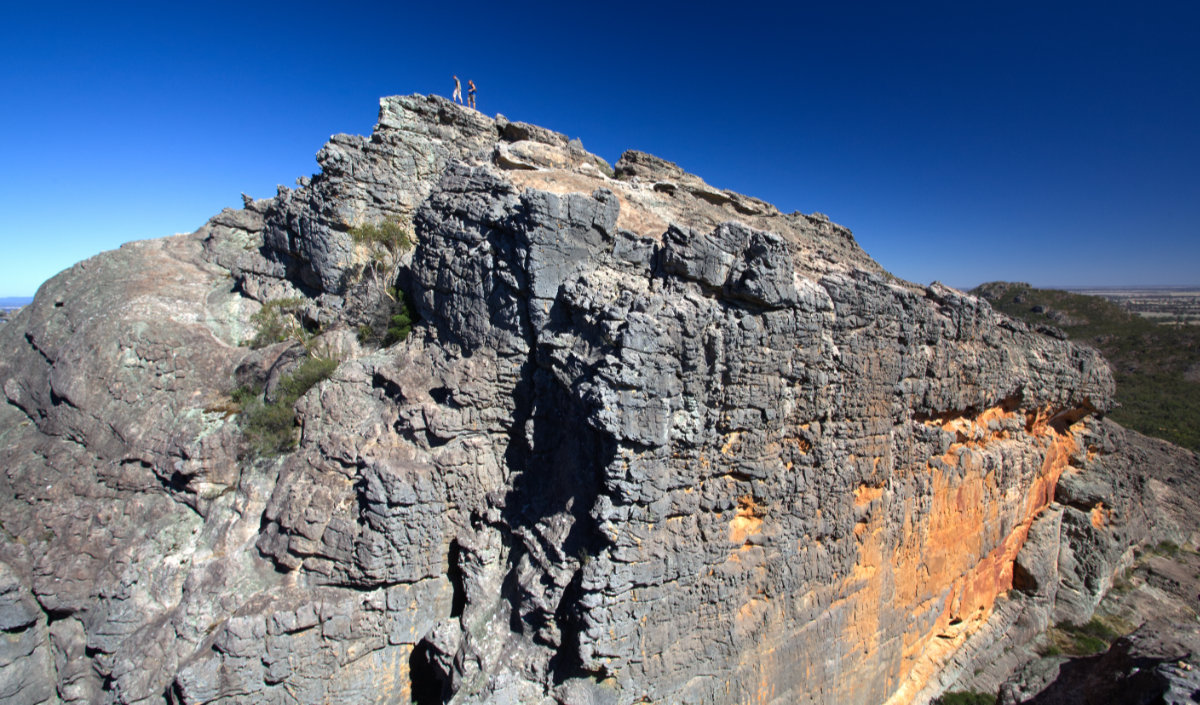
Just before last Christmas Parks Victoria finally released the Greater Gariwerd Landscape Management Plan. Unfortunately in Parks Victoria’s haste to ban rock climbing across significant areas of the park they also appear to have banned scrambling and in doing so they have effectively closed three of the best adventure walks / scrambles in Victoria. Two of these walks are described in our popular walking guide Daywalks Around Victoria (the Stapylton Amphitheatre walk [Hollow Mountain to Mt Stapylton] and the Fortress summit walk).

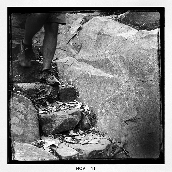
Here at Open Spaces we had concerned readers contacting us and asking for clarification. It’s no secret that Parks Victoria have closed a significant number of walking trails in the Grampians (possibly to funnel walkers onto their newly constructed Grampians Peaks Trail and to simplify management responsibilities and costs), but to have banned visitors to the Grampians National Park from undertaking any scrambling – an innocuous and common pastime for many outdoor enthusiasts – seemed to be too draconian even for them. Furthermore, there had been no hint of initiating such measures within the Greater Gariwerd Landscape Draft Management Plan nor in the public consultation process that preceded it. Back in 2019 and again in early 2021 Parks Victoria had even given us assurances that such adventure walking trails were open (although not officially recognised). Even as recent as March 2021 Jason Borg (Regional Director, Western Region) had continued to express support for these walks and even the use of safety ropes, safety harnesses and safety helmets both inside or outside of what Parks Victoria call Special Protection Areas (SPAs). To clarify, although the majority of averagely fit and able bushwalkers find these scrambling routes (such as the ridge-line linking Hollow Mountain to Mt Stapylton) to be both enjoyable, easy and straightforward, some walkers (especially those less agile within clubs or school groups) use safety ropes to provide a bit more security.

You can read our full blog relating to this matter and Parks Victoria’s detailed responses at Grampians National Park: Safety Ropes, Bushwalking and Special Protection Areas.

With the the release of the Greater Gariwerd Landscape Management Plan Parks Victoria included the following table (p99) which was added without any consultation with either the bushwalking or rock climbing communities.

It is difficult to know why Parks Victoria decided to hastily adapt the North American Yosemite Decimal System (YDS), which is what Parks Victoria refers to as the Sierra Club’s “modern classification”, to divide hiking and rock climbing into five general classes. According to Wikipedia, “the exact definition of the (YDS) classes is somewhat controversial, and updated versions of these classifications have been proposed”. In fact, the Sierra Club (which is California based) have now reviewed the YDS ratings system and have new “Scrambler” definitions “to distinguish them from the closely related but not identical YDS ratings”. There is also the question of where and exactly how does the North American YDS actually fit in with the widely accepted Australian Walking Track Grading System (of which Parks Victoria has endorsed) or with the long established Australian and New Zealand Ewbank rock climbing grading system.

However the real issue is with how Parks Victoria have used the Class 3 definition, which equates to “scrambling with increased exposure, where handholds are necessary and falls could be easily be fatal”. Parks Victoria has decided that class 3 scrambling is to be regarded as “hiking” but only if it occurs on a designated hiking trail. And this is where things get really strange. According to Parks Victoria if class 3 scrambling occurs on a non-designated hiking trail (such as on the Hollow Mountain to Mt Stapylton traverse or to reach the summit of the Fortress) then it is to be considered rock climbing ‘whether ropes or other safety equipment is used or not’. What this effectively means is that although this stops all those pesky rockclimbers in their tracks it also puts an an end to what many experienced walkers take for granted as part of their normal outdoor experience – scrambling. There must be literally thousands of established walking routes around Australia and throughout the world that involve sections of so-called class 3 scrambling. Surely Parks Victoria cannot be serious in banning something so innocuous as scrambling. So, we decided to clarify the situation by contacting Parks Victoria. Almost a month later we finally received the following reply:

To say we were confused is an understatement. The first paragraph states that “class 3 off-designated track scrambling is not permitted outside of designated climbing areas”, and the third paragraph states that “in respect to the Fortress and the Stapylton Amphitheatre walk as described in your correspondence, off track hiking is permitted”. As both the Fortress summit and the Stapylton Amphitheatre walks are indisputably classed by their own adapted YDS system as class 3 this means that these paragraphs are contradictory.

The rest of the letter told us that unlike 12 months previously, safety equipment can no longer be used by bushwalkers unless they are on a Parks Victoria designated walking trail. Again, very odd. Also, the walking and scrambling route to the top of the Chimney Pots is no longer allowed as it is now located in a Special Protection Area, yet this is again strange as there is a designated walking trail loop around the entire Chimney Pots, up against the cliffs. Apparently you can apply to walk and scramble to the top of the Chimney Pots but only after applicants “document this request in writing including details of when, who and why they need to walk in this area”. If it sounds like a ban and looks like a ban then it’s probably a ban!

This letter from Jason Borg left us more confused than ever. I therefore emailed Jason again to point out the contradictions and soon received an email back, not from Jason Borg but from Will Cox, the acting Area Chief Ranger for the Grampians National Park. Will Cox and I exchanged a couple of confusing emails in which he finally stated that “Parks Victoria will be conducting a review of these hiking tracks along with many other tracks throughout the park through its implementation of the Greater Gariwerd Landscape Management Plan. As you can appreciate, I can’t pre-empt any outcomes of this process”. I summarised the conversation with, “So if I understand you correctly walkers can walk these trails until further notice?”. Will Cox didn’t reply so I took this to be a reasonable assumption of the situation as it stands.

So there you have it. The Greater Gariwerd Landscape Management Plan has been released and scrambling may or may not be banned in the Grampians National Park. From what I can ascertain, this plan, even though it has been released, is exactly that, still a plan. Apparently Parks Victoria has communicated in writing that a set-aside will be posted on its website. However, if the plan is enacted as is, without changes, then class 3 scrambling will be banned and bushwalkers could be facing large fines for doing what many walkers around Australia and the world take for granted.

To be fair Parks Victoria appear to have painted themselves into a complicated bureaucratic corner over their hasty attempts to initiate sweeping rock climbing bans across the Grampians and in doing so have unfortunately caught up bushwalkers in the process. If our email conversations with Parks Victoria are anything to go by then it is obvious they are struggling with a complicated, poorly thought out and ultimately contradictory strategy.

KEY POINTS

  • Parks Victoria are in the process of banning class 3 scrambling in the Grampians National Park.
  • Bushwalkers are potentially facing large fines should they be caught class 3 scrambling on non-designated hiking trails.
  • According to Parks Victoria their class 3 definition is that ascending a given section of rock (whether it is 5m in length or 100m in length), whether with or without “ropes and other safety equipment” is “scrambling” if that section of rock is on a “designated hiking trail”; however, ascending that identical section of rock (whether with or without ropes and other safety equipment) is regarded as “rockclimbing” if it is not on a designated hiking trail. In other words, simply by designating a trail or by removing its designation, an ascent (whether with or without ropes and safety equipment) can be assessed as either class 3 scrambling or rockclimbing according to Parks Victoria’s whim.

If you wish to have an input regarding the future of walking and scrambling trails in the Grampians National Park, please consider writing to Parks Victoria. It would also help if you encouraged your bushwalking club to do likewise. If enough people voice their opinions then maybe Parks Victoria will be forced into revisiting this issue and come up with a less draconian solution, a solution that will benefit both Parks Victoria and bushwalkers alike. The following contacts include Bushwalking Victoria (who represent all bushwalkers in the state) and relevant Parks Victoria representatives:

Bushwalking Victoria:  admin@bushwalkingvictoria.org.au
Lily D’Ambrosio (Minister for Energy, Environment and Climate Change): lily.dambrosio@parliament.vic.gov.au
Matthew Jackson (Chief Executive Officer of Parks Victoria): ceo@parks.vic.gov.au
Jason Borg (Parks Victoria Regional Director, Western Region): Jason.Borg@parks.vic.gov.au
Will Cox (Acting Area Chief Ranger, Grampians National Park, Parks Victoria): will.cox@parks.vic.gov.au
Stuart Hughes (Director of Park Planning and Policy, Parks Victoria): stuart.hughes@parks.vic.gov.au

In the meantime I’d recommend that bushwalkers consult with Parks Victoria before undertaking any of the walks discussed here. Parks Victoria can be contacted on 13 1963 or via email at info@parks.vic.gov.au.
I’d like to also thank Parks Victoria for addressing our concerns.

The Fortress. One of the most attractive isolated rock summits in Australia and an historic bushwalking destination.


Posted on 5 Comments

Grampians National Park: Safety Ropes, Bushwalking and Special Protection Areas

This article was added to on 10 March 2021 to include a letter from Jason Borg at Parks Victoria.

Many of you are probably aware that Parks Victoria have initiated sweeping rock climbing bans across the Grampians National Park in what are called Special Protection Areas (SPAs). At Open Spaces we have received a number of phone calls and emails asking whether these bans will effect bushwalkers who use safety ropes within SPAs. At least two of our Grampians walks in our Daywalks Around Victoria guidebook are directly affected. These walks are Stapylton Ampitheatre and The Fortress Caves. So we decided to write to Parks Victoria to seek clarification. Here is our letter (dated 27 May 2019):

To whom it may concern,
Open Spaces are currently in the process of writing an online update to the four Grampians bushwalks we describe in our popular Daywalks Around Victoria guidebook. This book has sold over 3000 copies and we have a responsibility to the groups, clubs and numerous independent walkers to attempt to clarify the somewhat confusing situation regarding the current Parks Victoria Special Protection Areas (SPAs). Two of our described walks (the Stapylton Amphitheatre, p44 and The Fortress Caves, p50) appear to be affected by the SPAs.

As you are no doubt aware the Stapylton Amphitheatre walk (the rocky ridge linking Hollow Mountain with Mt Stapylton) has long been regarded as one of the most iconic walks in the Grampians, it has been called the most spectacular walk in Victoria and sees hundreds of walkers a year (both teenagers and adults). The Echoes Block section of the Stapylton Amphitheatre walk (at the point where you leave the main walking trail to Hollow Mountain) appears to be within an SPA. It is our understanding that there is now a ban on the use of safety ropes within SPAs. Unfortunately many groups, clubs and independent walkers commonly use a safety rope to gain the top of the Echoes Block. Although the scrambling is easy, it is the safest way to bring walkers up. Safety ropes have been used on the Stapylton Amphitheatre walk for at least 50 years.

We are writing to you to inform you that we will be advising our readers that if they resort to using a safety rope within an SPA they face possible fines of over $1600. We will also inform our readers that a safety rope is therefore not allowed to be used on the initial Echoes Block section of the walk but is allowed to be used on the final steep northern scramble up to the summit of Mt Stapylton (as this section is not within an SPA).

The final scramble up to the top of the Fortress is also regularly completed by groups, clubs and independent walkers. Some of these people rely on the use of a safety rope to gain what is widely regarded as the best summit in the Grampians.

Question one. Is the Fortress within an SPA? It is difficult to tell as the official maps are lacking in detail. If it is within an SPA we will inform our readers that the use of a safety rope to gain the summit is no longer allowed.

Question two. Has Parks Victoria considered that a no safety rope policy (within SPAs) will influence some walkers to forgo the use of a safety rope (due to the over $1600 fine) and which will almost certainly result in future accidents?

We understand that both of these walks are not officially recognised by Parks Victoria but considering that they are historically important, have a long history with walkers and are popular (particularly the Stapylton Amphitheatre walk) it would be hard for Parks Victoria to pretend that they didn’t exist, and therefore absolve themselves of any future responsibility.

Looking forward to your response, Glenn Tempest, Open Spaces Publishing

Here is Park Victoria’s response (dated 11 July 2019):

Dear Mr Tempest
Safety Ropes in Special Protection Areas

Thank you for your email of the 28th May, 2019 to the Hon Lily D’Ambrosio MP, Minister for Energy, Environment and Climate Change, regarding Special Protection Areas and the use of safety ropes while bushwalking in Grampians National Park. As this issue falls within Parks Victoria’s responsibilities, your correspondence has been forwarded to me for my consideration and response. I apologise for taking so long to get back to you.

While Parks Victoria prohibits rock climbing within Special Protection Areas (SPA’s) there is no prohibition on the use of safety ropes to assist with the activity of bushwalking either inside or outside of SPA’s. Safety ropes are permitted if necessary for safety while bush walking and National Parks regulations are complied with (i.e. no damage to rock or use of bolts, no trampling or damaging of vegetation). Parks Victoria would be interested in working with you to provide clarity to bushwalkers on what defines the use of safety ropes while bushwalking and how it can easily be distinguished from climbing.

To clarify your question regarding Echoes block and the Fortress: Echoes block is within an SPA. The area is of significant natural and cultural value, and is not on an authorized walking track. Although bush walking is permitted in this SPA, the nature of this activity is “off track” therefore, bush walkers are reminded to adhere to minimal impact guidelines (tread lightly, keep group sizes small, don’t damage vegetation) and comply with National Park regulations. Safety ropes if necessary, should only be used as described above and not be the primary means of access.

The Fortress walking track is an authorized walking track that sits within a remote and natural area, where the activity of bushwalking on and off track is permitted. However, the walking track itself has an SPA layer over its entirety for the protection of important natural values. The summit of the Fortress is not within this SPA as the authorized walking track does not continue to this area. Bush walking in this summit area will need to adhere to minimal impact guidelines and comply with National Park regulations. Care should be taken when walking off track to consider remoteness and difficult terrain.

As you may be aware, a new management plan is being developed for the Grampians landscape, an area that covers the Grampians National Park and adjacent parks and reserves. This document will underpin strategic planning for the Grampians landscape over the next 15 years to ensure the precious environmental and cultural values of this iconic landscape are preserved for future generations to enjoy. This includes providing longer-term direction on matters such as access and usage of the park. The process to develop this plan will include opportunities for you to share your thoughts, attend public information sessions, and get feedback from Parks Victoria and key stakeholders on specific questions that you may have.

I will have local staff from the Grampians National Park contact you to meet you on site and discuss these matters further.

Yours sincerely
Sally Lewis, Regional Director Western Region Parks Victoria

So, just to be clear. Safety ropes are permitted if necessary for safety while bush walking and National Parks regulations are complied with (i.e. no damage to rock or use of bolts, no trampling or damaging of vegetation). I’d like to thank Sally Lewis (Regional Director Western Region) and to Simon Talbot (Chief Operating Officer) and Gavan Mathieson (South West District Manager) for contacting me with regards to this important issue.

UPDATE 10 March 2021

In February 2021 we had some further concerns regarding bushwalkers using safety ropes when scrambling inside or outside of Special Protection Areas (SPAs). Some walkers had contacted us asking whether or not they were able to use safety helmets and safety harnesses (particularly in regards to children, those less nimble or those less confident in their abilities). We wrote to Jason Borg at Parks Victoria on 29 January 2021 asking for further clarification regarding the use of safety helmets and safety harnesses. Here is his reply.

Perhaps the following graphic will help clarify Parks Victoria’s logic. Or maybe it won’t.

Posted on 5 Comments

Silver Mine Walking Track

The Silver Mine Walking Track is located in the Snowy River National Park, one of Victoria’s most remote and least visited semi-alpine regions. By the time Karen and I parked our vehicle at the start of the walk at McKillops Bridge I had a fairly good idea as why so few people visit this place. The drive down McKillops Road is nothing short of frightening. Narrow, slippery and pot-holed, this veritable goat track winds down a seriously steep mountainside that was scarily reminiscent of the so-called roads I’ve too often encountered in the foothills of the Indian Himalaya. I for one was glad to have made it down to the Snowy River alive. I was still feeling wobbly-kneed as we set off along the Silver Mine Walking Track and I had to put in a big effort to keep up with Karen’s usual brisk pace.

Signpost at the start of the walk.

McKillops Bridge and the Snowy River.

After just a few hundred metres we joined Deddick Trail, which is actually a wide vehicle track. It was now becoming obvious to me that whoever named all of these roads and tracks definitely had a twisted sense of humor. Just as I was wondering how much more climbing we were going to have to do the signposted walk left Deddick Trail and plunged back down into the valley along Silver Mine Track.

Cliffs along the Deddick River Valley.

Wildflowers poke through the old tailings heaps.

Although the descent is very steep there are some wonderful views across the river towards Little River Gorge. A couple of old silver mines also help keep your mind off the relentless pounding of knees. By the time we reached the Snowy River we were getting very hungry. Anybody that knows Karen will also know that nothing is ever going to get in the way of a good lunch (or breakfast or dinner for that matter). We arrived at the Overnight Hikers Camp and made our way down to the river-bank where we spread out a feast of dips, ham, cheese, bread and fruit. We lazed on the warm rocks, dangled our feet in the cool water and watched a pair of eagles soaring high in the sky.

Up the steep Deddick Trail to the top of the range.

Cypress pine log cabin. Old silver mine relics.


After lunch we rejoined the walking trail, which now headed away from the river following a small heavily eroded gully and passing a few more long-abandoned silver mines. The remains of an old pine log cabin gave us some idea as to the hardships that these miners must have faced. The walking trail soon started climbing again and took us through stands of tall cypress pine via a long series of switchbacks. The unusual pine forest was reminiscent of walking through the valleys in Nepal. On top of the spur we made a short detour to the lookout. Here we could see the glittering Snowy River as it twisted and turned along the wide sandy flats. Today the river is but a shadow of its former self and I couldn’t help wondering what it must have looked like before we tore its heart out and redirected its once mighty flow into the Murray River, all in the name of progress.

The last section of the walk continues through more cypress pine forest and eventually we rejoined Derrick Trail at where we passed earlier in the day. We got back to the car at about 5pm.

Cypress pine forest.

The Silver Mine Walking Track is 16.8km, not 18km as the official signs indicate, nor 15.5km as the free park notes indicate. The walk takes about 5 hours but allow 6 hours to include lunch.

I’ve described the walk in detail in our recent Daywalks Around Victoria walking guide ($22.95), which is available from the Open Spaces online bookstore or from outdoor adventure stores and book shops.

You should also check out Parks Victoria Snowy River National Park page and download their Silver Mine Walking Track PDF.

The Snowy River, Snowy River National Park, Victoria.

NOTE:
The McKillops Day Visitor Centre is closed from 23 May to 15 June 2012 due to a goat control program. This almost certainly means that the walk will be closed also. McKillops Bridge is also closed for repair works until 22 June from 8am to 4pm. Check with Parks Victoria on 13 1963 for details.


Posted on 5 Comments

Grampians Peaks Trail (Feb 2012 Update)

mt rosea

mt rosea
The lookout on top of Mt Rosea in the Grampians.

Just finished chatting with David Roberts, Ranger in Charge of the Grampians National Park. Regular readers may remember the piece we did here on the Grampians Peaks Trail in July 2010. The proposed walking trail was to link Mt Zero in the north to the town of Dunkeld in the south, covering a distance of approximately 150km. This was easily the most exciting new walking trail project to have been planned in Victoria since the completion of the Great Ocean Walk in 2005.   Unfortunately nature intervened with the January 2011 floods and many walkers feared that the initial $1.6 million in funding would be withdrawn or redirected elsewhere. Thankfully this was not to be the case. David said that the final alignment of the trail was happening right now and that he envisaged construction of the initial three-day walking loop (from Halls Gap, through the Wonderland Range, across Mt Rosea to Borough Huts Campground and back at Halls Gap) would begin within 3 months. Two hiker camps will be constructed along the way.

This really is great news for what will hopefully become one of Australia’s premier long distance walking trails. The Victorian Government have also approved another $1.4 million for the next stage of the trail through 2012 to 2014.

Posted on Leave a comment

Problems With Falcons Lookout Walk and Ironbark Gorge Carpark

There are four official public entrances into Werribee Gorge State Park. The main entrance is via Myers Road on the eastern side of the park and is accessed via the Western Freeway from just past Bacchus Marsh. The other three entrances are located along Ironbark Road via Western Bluff, Ironbark Gorge and Ingliston Gorge Carparks. Western Bluff Carpark provides access to Western Bluff Lookout and is occasionally used by walkers descending the spectacular Needles Spur (through private property) into the gorge. Ingliston Gorge Carpark provides access to the Ingliston Block, the isolated western arm of the park, while Ironbark Gorge Carpark provides access to the Falcons Lookout Walk, the Ingliston Granites and Ironbark Gorge. Ironbark Gorge Carpark is also the nearest trail-head for Falcons Spur, an increasingly popular walk that descends into the gorge (again through private property). Falcons Lookout itself is one of the most popular rockclimbing destinations close to Melbourne.

Over the past year I’ve noticed that Ironbark Gorge Carpark has become increasingly busy. In fact it’s not uncommon to find 6 to 8 cars and perhaps a bus using the carpark on any midweek day. On the weekend I have seen up to 50 or more climbers at the cliff and perhaps a dozen or more walkers on the trails. This equates to at least a dozen or more vehicles crammed into the tiny carpark. I don’t know the actual park user numbers but I suspect that on many days there would be more visitors accessing the park through the ‘back-door’ of Ironbark Gorge Carpark then would be along the ‘official’ Myers Road entrance.

Interestingly, Myers Road is serviced by two large carparks (the Quarry Picnic Area and Meikles Point Picnic Area) and each have have picnic facilities, BBQs and toilets. In comparison, Ironbark Gorge Carpark is very small and rough to say the least. The geography of the area means that this carpark can’t be made much larger, but it could benefit from a redesign if it is to cater for the growing numbers of cars using it. The carpark also has no toilets. While this would be a minor issue for some, it is a major issue for many. Both walkers and climbers are forced to go bush and this is simply unacceptable at such a heavily used carpark as this. Perhaps having a toilet in the carpark would help to reduce the enormous number of poos and loo paper scattered around the vicinity of Falcons Lookout. In fact, the situation is becoming so bad at Falcons Lookout that perhaps the best thing to do would be to build a drop toilet on the adjoining saddle.

Which brings me to my final gripe. The initial section of trail (down past the old railway workers hut sites) into Ironbark Gorge is a complete disaster. The contractors that Parks Victoria used to ‘fix’ this section of the trail have done an awful job. If anything, the pine boards anchored across the trail has worsened the erosion and created a major eyesore. Simply put, this section of the trail is loose, ugly and dangerous. With the large numbers of people using the Falcons Lookout Walk you would have expected Parks Victoria to have properly fixed this trail a long time ago. Possibly the only way to save this trail now would be for Parks Victoria to contract a reputable construction company such as TTMS (Track and Trail Management Services) to rebuild it. Failing that (and knowing how little money Parks Victoria these days invest in high-quality long-term trail maintenance) it may be simpler, cheaper and quicker to realign this section of the trail down the spur 20m or so to the west, then cut it back to the point at where the original trail reaches the bottom of the initial gully. This would greatly reduce erosion problems and is where the trail should have gone in the first place.


Posted on 13 Comments

Melbourne’s Western Gorges On Sale Now

Great news. Our newest title, Melbourne’s Western Gorges, arrived in our warehouse this morning and will be in the shops from tomorrow. Authored by Glenn Tempest, this is the first in a new A5 series of walking guides to regional areas around Victoria. Melbourne’s Western Gorges covers 20 walks in the Brisbane Ranges National Park, and Werribee Gorge and Lerderderg State Parks. Produced in full colour with 96 pages it retails for just 19.95. Like our last book, Daywalks Around Victoria, this guide also features free GPS downloads as well as regular updates. Melbourne’s Western Gorges is also available in our online bookshop.


Posted on 4 Comments

Jawbone Track Repairs Finished

Last week Greg and I walked up to the top of the North and South Jawbone Peaks in the Cathedral Range State Park. I was really keen to check out the new trail work on the Jawbone Track leading up to the Farmyard. The 2009 Black Saturday bushfires really hammered this part of the range and, while this trail has always suffered from erosion issues, the fires made things a whole lot worse.

The initial walk up from the Jawbone Carpark is nicely contoured and Parks Victoria have replaced the original bridge over MacLennans Gully with a new steel construction. Hopefully this bridge will withstand future low and medium intensity fires. Personally I can’t see the need for expensive bridges spanning minor water courses that for 98% of the year can be easily stepped over, although I’m sure most walkers will welcome the convenience.

The trail up to the first rocks was realigned quite a few years back and it is still in excellent condition. From the rocks the trail cuts across to Jawbone Creek, crosses it and then climbs steeply up to The Farmyard. This section and the trail has always suffered from bad erosion and the 2009 Black Saturday bushfires made things a whole lot worse. If you’ve hiked up to the Jawbone Peaks since the park was reopened after the fires you will know that work on this trail has been progressing for sometime. As it is Parks Victoria and their contractors have done an excellent job. The careful placement and seating of large blocks (and all without the use of cement) means that the trail will be far more resilient to heavy foot traffic and now blends in really well with the natural surroundings. Two thumbs up for a job well done.

From The Farmyard we continued up to the top of South Jawbone Peak. Essentially the trail to the summit is okay but is now so overgrown as to be difficult to follow. In fact I would say that the regrowth is far thicker now than it was before the 2009 fires. What a difference a couple of years makes! While the hazel pomaderris is especially thick, it is the kangaroo wattle (or prickly wattle, acacia paradoxa) that is making life difficult for walkers.

Most likely much of this regrowth will die off over the next few years as the forest re-establishes itself, but in the meantime it’s a real pain. Maybe Parks Victoria should send in a crew to re-cut the trail although I’m not sure exactly how long this would last. Luckily the trail up to North Jawbone Peak is much better, but there are still short sections of thick regrowth and the kangaroo wattle is growing strongly on the upper rocks near the summit.


Posted on 10 Comments

Ninety Nine Years Around Powelltown


Each spring I set aside a day to walk the remarkable tramways that weave through the forested hills surrounding Poweltown in the upper reaches of the Yarra Ranges. In 1912 Poweltown was born when the Powell Wood Processing Company opened a large mill on the banks of the Little Yarra River. The steam train had arrived in nearby Warburton in 1901 and the timber industry flourished in its wake. Hundreds of men were employed to fell the tall trees, mainly to supply the rapidly expanding growth of Melbourne and Geelong. In those days it seemed that the forests stretched forever. This was an era of selective logging, long before mechanisation stole most of the timber-worker jobs and long before wood-chipping and clear-felling became the norm. Ninety nine years ago the loggers of Powelltown would cut the trees by hand, using cross-cut saws and axes. It was a dangerous game and loggers were a genuinely tough breed.

Steam-powered winches would pull the logs up through the forest to narrow-gauge tramways, which were used to transport the timber to nearby sawmills. One of the best walks in the area follows the Walk into History, which utilises various tramways linking Big Pats Creek with Starlings Gap and then on through the Ada Valley. Along the way there are plenty of reminders of the past. Occasionally you will find a collapsing trestle bridge balancing across a creek or gully, thick green moss hanging from its now rotting beams. Twisted metal tramlines hide among the leaf litter, sometimes still attached to their original sleepers. Large metal boilers, rusting bogies, pin couplings and various bits of machinery sit quietly beneath the blackwoods and mountain ash. Ninety nine years of history, slowly being swallowed by the bush.

Posted on 4 Comments

Maps, Meridians and the Whole Damm Mess

As spring quickly approaches I thought this would be a good time to go over a few navigational basics and explain how they relate to our new walking guides.

In 2000 Australia changed over to GDA94 (Geocentric Datum of Australia), which was defined in 1994 and based on WGS84 (the World Geocentric System developed in 1984 for use with the satellite Global Positioning System). Essentially GDA94 and WGS84 datums are the same for recreational purposes such as bushwalking. Most current-edition Australian maps now use the GDA94 datum (earlier maps were based on the Australian Geodetic Datum systems AGD66 and AGD84). Bushwalkers using the maps in this guide (or downloading our GPS data) should set the datum on their hand-held GPS to GDA94 or (if this is not an available option) to WGS84.

• There are two sets of lines drawn across each map. Those that run north-south are called eastings and those that run east-west are called northings.

• Intersecting eastings and northings form grid squares with each square representing 100 hectares or one square kilometre. The maps in our guides are not created to a set scale so it is important to look carefully at the scale icon and/or the grid to ascertain the distances involved

• Grid north points to the top of the map (when viewed the correct way up).

• In the map/text example, each segment of a described walk is indicated by a location marker showing the distance travelled (in this case 10 and 12.3km) and the name of the location (such as Erskine Falls Carpark). The text reflects this information with the addition of the full grid coordinates as taken directly from the GPS.

• In the map/text example, the two digit grid numbers in the margins of the map correspond to each grid line. These numbers are abbreviated and are underlined (for easy reference) in the GPS grid coordinates.

• In the map/text example, the GPS grid coordinates show the number 54. This is the UTM (Universal Transverse Mercator) zone number (the earth is divided into 60 north-south zones). The letter H indicates the UTM zone designation letter. Together the UTM zone numbers and designation letters provide what is called a Grid Zone Designation. In a nutshell, Victoria (for example) is divided into two zones: 54H (covering the west side of the state and 55H (covering the east side of the state).


How to download GPS tracks

• Many of our described walking trails has been mapped using a hand-held Garmin GPSmap 60CSx device. Each GPS track is available as a free download at osp.com.au in both .gpx and .kmz files.

• If you don’t own a Garmin GPS device, don’t fret. All of our original Garmin .gdb files have been converted to .gpx files (GPS eXchange Format). This popular open format is commonly used to exchange waypoint, route and track data between various brands of GPS devices and mapping software.

• All of our .gpx files have been simplified to under 500 track points for faster downloading.

• Waypoint data is provided on all our .gpx files and will be kept up to date where possible.

• A .kmz file will open in Google Earth just by simply double clicking on it (as long as you have Google Earth installed on your machine). Google Earth also has native support for .gpx files containing GPS data. In Google Earth go to File > Open and navigate to your folder containing the downloaded .gpx file. If you cannot see the .gpx file in your folder try selecting the right file type (All File Types). Open the file.

• Remember that you will need to be running a software program to handle your .gpx files. These programs usually come with your hand-held GPS device. The program we use with came with our Garmin and is called MapSource. Garmin also have free software called BaseCamp. There are many others on the market.

Just a final word of caution. The maps within our walking guides provide a basic overview of each trail, but are not designed to be used in conjunction with a compass, and cannot replace the accuracy of detailed contour maps such as the Vicmap 1:25,000 series. In other words, use a large contour map, carry a compass and/or a GPS and make sure you have a firm understanding of basic navigation. Hand-held receivers have become very affordable in recent years and are increasingly popular among bushwalkers. A GPS user can accurately pin-point a location at any given time. It’s important to note however, that a GPS is only as good as it’s batteries (or fumbling fingers) and that basic map-reading and compass skills are still required.

Posted on 1 Comment

Mt Beckworth Walking Trails

The Lollipop Tree was planted on the 634m summit in 1918.

We visited Mt Blackwood Scenic Reserve last weekend to check out the local walks and finalise the relevant GPS data and details. We are featuring one of the park’s walks in our forthcoming walking guide to The Goldfields. The park has only recently reopened after the storm damage that occurred in January 2011 and Parks Victoria had indicated (on their web site) that it was only open to 4WDs. I visit Mt Blackwood fairly regularly (both as a walker and rockclimber) and was expecting that a lot the rehabilitation work would have been completed. Unfortunately this was not to be the case. The vehicle tracks are still in a terrible condition (sections of which are still closed). However, it was the poor standard of the walking trails which really caught my attention (and which could not be attributed to just storm damage).

Someone must have found this sign threatening so shotgunned it to death.

Back in 2001 we released Daywalks Around Melbourne, which featured a couple of walks in the Mt Beckworth Scenic Reserve. At the time I was critical about the quality of the walking trails which were in various states of disrepair. Over the intervening 10 years it would appear that little or no maintenance has been carried out. The result is a network of walking trails that are at the point of no return. The standard of the trails are so bad that in places erosion has completely destroyed the surface. Fallen trees are common and some trail sections vanish altogether. Yellow Box Track (which is clearly marked on Park Victoria’s Free Park Notes), has simply vanished. Short sections of the trail can still be seen but most people will eventually lose their way. What makes all of this worse is the almost complete lack of trail markers and directional signs. In just a couple of more years the once lovely walking trails of Mt Beckworth Scenic Reserve will probably be just memories and the park will be a lesser place because of it.

This tree has collapsed over the trail, which is now almost impossible to locate.

Even the newest signs in the reserve are falling to bits.


Ok. It’s now April 2015 and one of our regular readers (and users of our walking guides), David Sidwell, recently posted an article on his website regarding some upgrades to the signage and walking trails around Mt Beckworth. You can read his piece here.