

Parks Victoria has moved to start work on the much anticipated long-distance walking trail traversing the length of the Grampians National Park. This project has been a long time coming and one of which has been of particular interest to myself and to a number of other Victorian bushwalkers who have talked about just such a walk over the last 20 years or so.
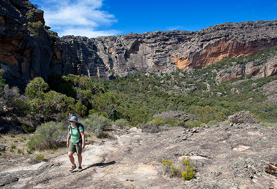
The proposed Grampians Peaks Trail will link Mt Zero in the north to the town of Dunkeld in the south. The total distance will be approximately 148km and should take most walkers between 12 and 14 days to complete. The first stage of the Grampians Peak Trail will be to create a three-day walking loop from Halls Gap to a proposed new Rosea Hikers Campground then on to Borough Huts Campground to eventually finish back at Halls Gap. Funds of $1.6 million were approved by the Victorian Government and announced on 29 June 2010. Walkers will be able to complete sections of the trail, shorter loops or walk the entire distance (known as ‘through walkers’). The southern section of the walk will follow the Mt William Range all the way to its end (crossing Yarram Gap) to cross back over to the Serra Range and on to Signal Peak, Mt Abrupt and Mt sturgeon.
This afternoon I chatted with Graham Parks, District Chief Ranger of the Grampians National Park about the trail. He felt that this was a really exciting concept and that the first stage of the walk would be completed within 2 years or so. Funding after this period should see the entire trail completed within 5 years.
The construction of major new walking trails has largely been forgotten in Victoria, and (partly) due to funding cuts to Parks Victoria many of our best established walking trails are now in various stages of disrepair. This is especially evident in our alpine areas which has had no real trail development for as long as I can remember. Other states such as the Northern Territory (the Larapinta Trail), Queensland (The Fraser Island Great Walk) and Western Australia (the Bibbulmun Track) have recognised the importance that high-quality long-distance walks bring to their tourism industry. It’s also worth noting that each of these walks are carefully designed so that sections of the trail can be completed in shorter day stages to cater for the growing numbers of daywalkers.
Probably my greatest concern regarding the Grampians Peaks Trail was where it would be routed (especially in the Southern Grampians). I feared that Parks Victoria would take the soft option and use fire-breaks and 4WD tracks to save themselves money and time. I was pleasantly surprised when Graham said that about 60% of the walk would follow newly constructed dedicated walking trails and that the rest of the walk would follow established walking trails (many of which will be substantially upgraded). That means no walking along 4WD tracks. A big tick here. We only have to look at the Great Ocean Walk to see just how a walking trail should NOT be designed. The Great Ocean Walk follows too many shared-use 4WD tracks and has earned it the unfortunate nickname as the Not So Great Ocean Walk. Long-distance walks require a complete avoidance of all roads and 4WD tracks (except where it is necessary to cross them). It is easy to push walkers along an established 4WD track to save money (instead of constructing a dedicated walking trail) but this only serves to greatly reduce the natural experience that walkers rightly expect. Once the designers of these trails realise that walkers do not want to share their space with vehicles then maybe Victoria will see some better trails constructed. Having talked with Graham today I felt that maybe Parks Victoria have learned from their Not So Great Ocean Walk mistake and that the Grampians Peak Trail will eventually become one of the best long-distance walks in Australia. Keep your fingers crossed.
For those interested in the the strategic direction of our parks and the proposed four wild walks you may wish to download Victoria’s Nature Based Tourism Strategy brochure here.
I’ve seen a detailed route proposal and I think it’s great. Much better than the cobbled-together Great Ocean Walk. I like the way that one section of the route does not traverse the highest peaks but stays on a lower parallel ridge allowing great views over to the main ridge line.
I agree Monica, the proposed route seems to have been well thought out. I have yet to see exactly where the camping areas are to be placed though. As for the Great Ocean Walk, I have a friend who did it recently. He was instrumental in the creation of the Larapinta Trail and while he enjoyed the Great Ocean Walk experience he believed it was severely flawed and could have been designed much better.
Hi
I’m making a documentary on hiking in the Grampians so the Peak Trail is an interesting/exciting development. The proposal is great as I think The Grampians possibilities for hiking are massively under utilised. The comfort thing is a bit of a worry, maybe half the track could be that style and the other half a bit more wilderness type.
Is there an available map of the proposed track it doesn’t sound like it goes through the Victoria Range which I think has some of the best places in Grampians eg The Fortress and Manja Caves.
Does anyone know the reason its going Sth-Nth which is starting off with stepper/harder walking and ending on relatively easy terrain. Warming into it maybe better.
Dave
Hi Dave. I haven’t seen a map of the proposed walk but I know where it roughly is supposed to go. You are right, it will not go through the Victoria Range. It will traverse the southern section of the Mt William massif and cross back to the Serra Range to climb Mt Abrupt before continuing on to Dunkeld. The Victoria Range has a 4WD track running along the length of the range and which spoils any wilderness aspect the Victoria Range could possibly have with regards to a long distance walk. I personally would love to see the Victoria Range Track closed to vehicles. As for going north – south I can’t really see much difference. And anyway you can still walk it south – north if you wanted to.
Hi Glen
Thanks for the reponse. I couldn’t agree more on the Victoria Range being closed to 4wd. I aksed Parks Vic why there is only one offical hiking track in the Vic Range (Fotress loop) and they said they want to minimise impact, I would’ve thouugh 4wd would more of a problem. Does anyone know any of unofficial walking tracks in the Vic Range that avoid walking on the goat track or 4wd tracks to get o Syphon Rd? Or a good place to find information on walking tracks not on the officical Grampians map?
Dave
Hi Dave,
The Victoria Range is a good example of how Parks Victoria likes to pretend they are maintaining a low impact area but in reality they have a major 4WD track running across its length. This is not a low impact area. It’s such a contradiction. For years I have been of the opinion that the Victoria Range Track should be closed. Currently much of the walking in the Victoria Range is along 4WD tracks and this is just not good enough. There are no walking trail links between the Goat Track and Syphon Rd. In fact the Victoria Range is pretty much a wast when it comes to well-constructed walking trails. The only reason the Fortress walk was designated an ‘official’ trail was because so many climbers and walkers were using it. Of course there are a bunch of unofficial trails which criss-cross the range but these are fairly tough going and mainly involve rockclimbers pads. Parks Victoria really don’t have the money or resources to construct good walking trails in the Victoria Range which is a great pity. I would, however, love to see the Victoria Range Track closed. It would be a good first step to making this range something really special.
Hi Glen
Sorry about the delay have been away for work. I hear your frustration on the lack of walking tracks in the South West of the Grampians. I spoke with Parks Victoria about a documentary I want to make on hiking in the Grampians. I expressed my surprise that there is only 3 overnight hikes in the whole park, one being The Fortress and I encountered again the ‘it’s a wildnerness area’. I said 3 hikes isn’t much considering you can 4wd to every corner and in between of the park! It’s a pity there isn’t more funding for tracks but they don’t need to all be established major comfort camp sites, perhaps the Western Grampian could be wilderiness hiking, single file tracks with a clearing at the end of each day for tens and one drop dunny. Fingets crossed the peak trail is completed in 3-5 years.
For updates on my doco check out and join – http://www.facebook.com//#!/pages/David-Willing-WriterDirector/145392502165876
If facebook doesn’t work try
http://www.davidwilling.com.au
http://www.facebook.com/profile.php?id=563952029#!/pages/David-Willing-WriterDirector/145392502165876
Hey there, the info on this walk has gone a bit cold over the past 12 months or so. Do you have any other recent news about it?
I’m guessing it’s on the back burner since the floods?
Hi Greg. I decided to call David Roberts (Ranger in Charge, Grampians National Park) and have a chat to him about the status of the Grampians Peak Trail. It’s all good news. Looks like construction begins in about 3 months time. Check out the update post we published today. http://osp.com.au/?p=2699
Cheers.
Just doing some net research on the Gramps Peaks Trail and found your discussion. Thought I would add my thoughts to the chat.
As always things are never straightforward. On the surface it may appear that the current alignment of the Great Ocean Walk is flawed and poorly designed. However, having been involved with the environmental assessment for the GOW from the beginning, I have come to appreciate the complex set of constraints that have a large influence over the “ideal” walking track route. Land tenure, cultural issues (indigenous and european), cost, terrain, legislation and policy, accessibility and safety are just some the issues planners need to consider when designing a track like the GOW. The ideal user experience has to be balanced against all of these factors.
In particular with walks in places recognised for their natural significance (ie National Parks), the environmental impact of the proposed development is a key issue. For example, an ideal alignment of a section of walking track may in fact place sensitive environmental sites (eg threatened species populations) at risk. These environmental values are often protected by state and national legislation. An alternative and less appealing track alignment may be required.
Having worked with Parks Victoria staff on these projects I can assure people that they are working hard to deliver the best outcomes for all users and the natural systems they are managing on our behalf. Another thing to keep in mind is that with large projects like these, progress is often completed in stages over a number of years. More recent realignments and upgrades of the GOW in the Moonlight Head area to reduce usage of vehicle tracks are an example of this.
All of the above issues are likely to apply to the Gramps Peaks Trail as well.
Cheers
Rob
Thanks Rob, your comment is reasonable and makes sense. I confess that when I completed this walk for the second time it had improved (in many ways) from the first time I walked it. I have since talked to a number of overseas visitors (who completed the walk) and who enjoyed the GOW but pointed the finger at misleading marketing. In its current state it is certainly a good walk but not what I would consider a ‘great’ walk of the ilk of such iconic multi-day classics such as the Overland Track, Larapinta Trail or the Jatbula Trail. I feel the GOW is on par with the New Zealand Abel Tasman Coast Track, which although listed as one of the official ‘Great’ walks is in fact flawed due to a whole variety of reasons. I’m really hoping that the Grampians Peak Trail will be something special as Victoria has for many years been left far behind most other states when it comes to the construction of high-quality (dare I say ‘world-class’) multi-day walking trails.
Rob & Glenn
I just happened to come across these posts when researching something else.
A couple of months back Parks Victoria established a Task Force to advise on the development of the GPT and invited Bushwalking Victoria to nominate a representative to be on it. Of course BWV accepted the invitation. I don’t yet know who the other representatives are but when I discussed our involvement with the District Chief Ranger he said there were a range of local and community groups represented.
As far I am aware at this stage there have only been one or two meetings. I am more than happy to receive suggestions, recommendations, feedback etc as the development progresses.
Hey Chris,
Thank you for the info regarding the GPT development Task Force. Really glad Bushwalking Victoria will be represented. This is quite possibly the most important new walking trail so far conceived in Victoria. We Victorian’s have been left a long way behind some of the other states when it comes to longer multi-day walks. The GPT will be a good first step towards rectifying this situation.
Be careful what you wish for re. the closure of the Vic. range road..it may happen (though it’s more likely just to be made MVO as some of it is already), leaving all of us with our varying uses of this part of the park with little acess.
I’m not sure I understand the that the vic range would be more of less “wilderness” according to one road..for a start if you close the road it will still be there..if you drag tree stumps and rocks onto it to stop the 4wd’s, then you will be left with a parks style walking track eg hut crk track or stockyard creek..and then your’e walking on a 4wd track again and I agree, no-one really wants to do that.
I doubt that parks have the money or time or inclanation to open any new short to medium walks in the grampians in general less in the vic range, for example how long has the Major Mitchell area been closed?It’s possible that this area may be closed to all “legal” walkers until the peaks track passes through.
Back in the vic range though it worries me that people split into their small intrest groups and point the finger at others, the reality is that managers are just as likely to lock out 4wd’s as they are to move on climbers and rub out old walking tracks…we’re all in the same boat here.
I assume by now you have a picture of me as a stroppy 4wdriver…..but it’s walking acess which worries me the most..with small children we are very much in need of acess roads to get us closer to interesting areas, Mt Thackeray is an exellent example as are the non listed art sites on this road and the Goat track.
On the other hand when walking without children walking in the vic range would usually involve no track at all…which is great, but not for everybody..
Back on the subject of the peaks walk, I agree that staying away from vehicle tracks is the answer to a great walking experience…but closing a vehicle track doesn’t make it a walking track…
thanks for the chance to get on my soapbox
cheers
Hi Dean,
You are quite right when you say that closing a vehicle track doesn’t make it a walking trail. I too would not like the Victoria Range Track closed but then retained as a MVO (management vehicles only). This would be of no use to anyone (except perhaps Parks Victoria who would have less management problems). To be honest I can’t see that the Victoria Range Track will ever be closed, especially as there is not enough money to properly rehabilitate it to a pleasant walking trail. However, I’m really hoping that the Grampians Peaks Trail will be something special and not be compromised for expediency or lack of funding.
My view of the Gramps is that it provides (or maybe used to once…) a really good mix of opportunities for walking, 4wds, motorbikes, climbing, fishing etc. The Vic Range is one of my favourite places in the Gramps and I like the fact you can do a bit of everything in that area away from the crowds. I may be weird but I like hiking, off road driving, riding motorbikes, camping, mountain bikes and even the odd bit of climbing. I draw the line at riding horses but only because they have no brakes and I cant fish to save myself.
Should also add to my previous point re Parks Victoria staff trying to do the right thing. By this I mean individuals I have worked with. In general I have many concerns with the direction of park management in Victoria. In particular, calls for commercial development within National Parks (see the government’s recent announcement on this issue) and the disproportionate priority given to providing a “safe” environment (driven by fear of litigation) for park users frustrates me no end.
I also digress….
Agree on the minimal use of vehicle tracks for the GPT. The whole point of walking is that you can traverse areas you couldn’t otherwise access. This provides the unique experience people are looking for. It’s a reward for your effort. As I mentioned above there are always constraints to achieving this, but in general, purpose built walking tracks are the go for “icon” walks in my opinion. I also hope for a really great walk but the reality is that there will be compromises.
Sorry also meant to say thanks Chris for the heads up on the Task Force. Happy for you to use any of my comments/feedback posted here. Cheers Rob
Hi Glen
I happened upon this website and the Grampians topic tonight and there’s some great stuff here.
From my ‘inside’ experience of the tracks and trails business in Vic, the state Native Vegetation Framework is the main killer. It has just been revised and things may change, but it virtually prohibits the creation of new trails, no matter how small, how innocuous, how sensitively constructed, through native veg, especially in unique environments like mountain ranges (Gramps) and coast (Great Ocean Walk).
The killer is the ‘Avoid, Minimise, Offset’ requirement: firstly a trail planner (eg Parks Vic) must show that they’ve avoided loss of native veg where possible, usually by using existing tracks. If they can’t ‘avoid’ they must ‘minimise’, again usually leading to the use of existing tracks but also leading to very expensive and high maintenance construction strategies like board walking to leave ground cover veg intact (i.e. not to cross an otherwise boggy or extremely sensitive environment but just to avoid clearing vegetation).
Finally, if avoiding and minimising are archived but clearing is still required, the cleared vegetation must be offset. Offsetting is done through a very complicated DSE-led process. A real example I am familiar with from the Surf Coast Walk project near Aireys Inlet is an offset cost of $620,000 for 2km of 0.5m wide walking track.
By the way, the Framework draws no distinction between public-good projects like recreational trails and for-profit projects like housing developments.
The Framework is the main reason why trail projects are so slow and expensive in Vic and why trails that should be wonderful are often not due to their use of horrible old existing tracks.
I hope this sheds some light on an issue that is not well understood amongst outdoors people and trail lovers.
Cheers, Mike
the master plan for this has been released
http://parkweb.vic.gov.au/explore/parks/grampians-national-park/plans-and-projects/grampians-peak-trail
The first stage is virtually complete for all to see.The campsite on the slopes below the Sundial (opposite Rosea) are substantial. It will be interesting to see how much usage it gets so close to public roads. The section of track from Borough Huts to Rosea is an impressive engineering feat.
My one observation is that with all this ” new track” it seems ridiculous that Mountain Bike trails are still taboo in the Grampians. Otherwise well done to all those involved.