
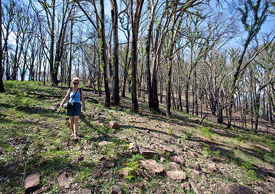
Tracey and I paid a visit to the Cathedral Range State Park last Wednesday. Tracey was there in her official capacity as the Victorian Climbing Club (VCC) Access Officer and was checking out the climbing access trail up to North Jawbones – one of the most popular and important climbing crags in Victoria. I was there to help her out and to shoot crag images for our forthcoming Selected Climbs Around Melbourne guidebook. At 9am we met Rhyl Shaw, the friendly Parks Victoria ranger, at Sugarloaf Saddle and she kindly showed us around and answered our questions. Rhyl not only has an intimate knowledge of the park but she is also an experienced bushwalker, rockclimber and cross-country skier. We could immediately see what an enormous job Rhyl and Parks Victoria was facing. During the Black Saturday fires the bulk of the park was burned and almost all of the walking trails were reduced to a tangle of fallen timber and unstable soil. The hardest hit area appeared to be around the Sugarloaf Saddle and up on the peak itself. Amazingly the lower part of the valley (along the Little River) missed out on the fires altogether.

In 35 degree heat (a big thankyou to our early November heatwave!) Tracey and I walked up to North Jawbones. The official walking trail has been (mostly) cleared and is now in surprisingly good condition. A much bigger problem however is the climbers trail which ascends directly up to below the cliff. I don’t want to pre-empt Tracey’s official report but I can’t see that this trail will be able to take much future foot traffic without creating major erosion problems. The same goes for the climbers descent down the north ridge of the North Jawbones which appears to be even more unstable. Tracey is already working on possible alternatives. The base of the North Jawbones has been well and truly cooked. In some places large rocks and boulders have shattered in the heat. Fortunately the bulk of the cliff and all of the routes look fine. Many of the bushes (some traditionally used for belays) have been burned so climbers will need to be careful when the area reopens. Tracey is right now preparing a more detailed report which will appear in Argus, the VCC newsletter.

From the top of North Jawbone we sat and soaked up the views. When the park reopens both walkers and climbers can expect to see a very different vista. There are now far more open views, a lot less trees and newly exposed rock faces are dotted across the range. The trees are now fringed with bright green epicormic growth and the ground is covered in a bewildering array of colourful wildflowers, some of which I’ve never seen in the park before.
The Cathedral Range State Park will hopefully reopen to the public around Christmas. On one level I was stunned by the amount of damage the fire has caused but on another level I felt privileged to be a witness to what is a natural process of the forest’s life cycle. The Cathedral Range State Park is every bit as magnificent as it always was; it’s just very different.
I really enjoyed reading this article, keep up writing such interesting articles!
Did the Cooks Mill and Neds Gully areas survive the fires? Myself and a mate camped there a few days over last new years 08/09 and I was devastated to hear that the park had been wiped out in February. By the sounds of it, the lower campsites survived though…is that right?? It is/was such a beautiful place.
Hi Nick,
Considering the extent of the fires and the damage, interestingly the campsites did survive. Untouched. Except on the outskirts of them, you wouldn’t know a fire had been there. It is a beautiful place – one of my favourites. Landscape is very different now of course, but new growth is starting to come back in some of the areas which is encouraging. Other areas took more of a beating. It will take a while but in the long term, the park will benefit from it. What was great to see were all the wildflowers.
The climbers descent off the top of the Nth Jawbones crag heading nth was indistiguishable. IE; we could not find it at all ! 11-12-2012. Besides the orange arrows pointing west towards the ridge walking track which in hindsight we should have taken, is the climbers decent still accessable behind Xenathine? Epic walk out. Any help would be appreciated. Prickly scratched Kev.
The old ‘climbers descent’ (running north behind the routes Bath Time Gurgles and the American Dream Area) should no longer be used as it is loose, unstable and full of prickles. The easiest walking descent is described in our Rockclimbs Around Melbourne guide. That is heading west following the orange triangles down to the saddle. Leave the main walking trail here and follow the lesser trail north down the shallow gully before cutting back right to back under the American Dream Area. Alternatively there is now also a rappel descent down Travellers Slab and Route Two. The rappel is described in detail on our update page here http://osp.com.au/?p=1425. Hope this helps.