
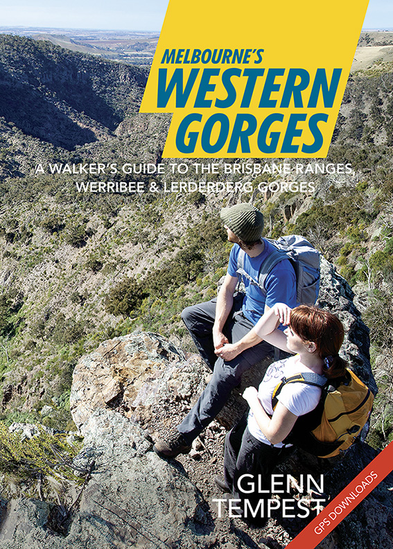
 Great news. Our newest title, Melbourne’s Western Gorges, arrived in our warehouse this morning and will be in the shops from tomorrow. Authored by Glenn Tempest, this is the first in a new A5 series of walking guides to regional areas around Victoria. Melbourne’s Western Gorges covers 20 walks in the Brisbane Ranges National Park, and Werribee Gorge and Lerderderg State Parks. Produced in full colour with 96 pages it retails for just 19.95. Like our last book, Daywalks Around Victoria, this guide also features free GPS downloads as well as regular updates. Melbourne’s Western Gorges is also available in our online bookshop.
Purchased! Suffice to say, I was a bit excited about this one! Thanks OSP!
Thank you Neil. You are officially the first person to purchase a copy of Melbourne’s Western Gorges. Hope you enjoy it.
Also have ordered (perhaps a I am officially second?) and really looking forward to the book.
Lerderderg is an absolute favorite of mine and happy for more excuses to revisit…
Thanks Matt. Yes, you are officially the second person to purchase a copy of Melbourne’s Western Gorges. I agree with you about Lerderderg Gorge. It’s a wonderful place and most Melbournian’s don’t even know it exists. Enjoy the book.
Lets hope it stays that way. 😉
Thanks Glenn… It’s a privilege! I start 5 weeks of holidays next weekend so I’m hoping to put it to good use!
My partner and i just returned from a 2 day hike in the Lerderderg, we’ve combined the Scenic Rim with the old River walk. It was great! We used your book Daywalks around Melbourne and your descriptions have been very precise and extremely helpful!
Thank you so much!
Anna and Ryan
Hi Anna. I’m really glad you had a good time. The gorge is an amazing place and yet most Melbournian’s have never even heard of the place. Probably a good thing too….
I successfully used your GPS map on my Garmin last weekend on the Werribee Gorge and found it invaluable for navigation. Thanks Glenn, can’t wait for all your books to hve these GPS maps.
Great publication Glenn. Just attempted Walk 14 today, the East Walk. Track was very haphazard and hard to follow in parts (orange ribbons hanging from trees helped as did chainsaw work on fallen trees) but after two hours of walking (scrambling), hadn’t quite reached Nolan Track junction 5.2km mark so decided to head back. Probably need to start a bit earlier next time as I think it may take closer to 6-7 hours to complete. Prefer to hike in the winter to avoid the “joe blakes”!!! Completed Walk 6 Werribee Gorge Circuit Walk earlier and this was a beauty, kids love all the cable assisted river cliff walking.
Hi Bruce. Sorry to hear about the East Walk now being hard to follow. It was such a great and varied walk. Easily one of the best in the gorge. Parks Victoria are so strapped for cash (and personnel) that very little trail maintenance gets done on it anymore (especially since the floods a couple of years back). If I were a pessimist I would be almost suspicious that it is in PVs interest (easier and cheaper) if more trails such as East Walk just return to the bush. I can remember about 12 years ago running this walk and it was a very enjoyable outing which took me a couple of hours. The trail was easy to follow. So sad.
Hi Glenn, we purchased your book Melbournes Western Gorges about 18 maths ago, and proud to say that today , after doing Bears Head cuircuit , we have now completed all the walks in your book for Werribee gorge; Lerderderg state park and Wombat state forest !
A number of them we’ve done multiple times and we are just loving exploring these beautiful areas, we are so lucky to live close by.
(Haven’t done any of the Brisbane Ranges walks …yet).
Only a couple of times we’ve found your descriptions hard to follow…mainly Yankee Gully and 1 section of The Tunnel walk. Thanks so much for a great , very user-friendly book and giving us the confidence to do these walks!
These trail updates were received by Louis Helbig with regards to Walk 16, The Tunnel.
Hi Glenn, as discussed, here are some notes on The Tunnel Track in Lederberg Park.
The first section, the path from O’Briens Crossing (Byers Back Track and Gribble Track) is as described. Only change is that the toilet block appears to be new.
@2.7km, the Tunnel to @ 4.2 Ambler Lane: the trail on the opposite river bank from The Tunnel has more or less disappeared. After a bit of bushwacking to the north, on the bench above the river, a track does eventually appear which leads between the ruined hut and the river. From here the track is intermittent winding through the ‘WW1 ruins’ more or less staying at a level elevation over the river. After the sweeping bend there are two tracks. The first, as described in the book is pinched off by a small cliff which can be traversed by most adults (but not by our 4 year old). The second climbs steeply above, over and to the right of the cliff below. This trail is clearly defined and is marked by faded pink flagging ribbons. Once over the top of the cliff the trail descends into another area of old mine working where it again becomes poorly defined. It eventually enters into an area of well trammelled mine tailings surrounding where Ambler Lane intersects the river.
@4.2km Ambler Lane to ‘Short Cut Track’ ( the 2km circuit that is still maintained by Parks Victoria) @6.2km. More or less as described except that the trail is poorly defined. The occasional bit of fading pink flagging tape helps guide the way. The area along the river before the ‘ broken cliff’ has significant number of tree trunks and other debris that has been washed there from when the river is in flood.
In all a great walk. It would be wonderful if Park Victoria were to clearly mark this trail again. The fading, disused trail from the Tunnel to ‘Short Cut Track’ is quite unique both for the terrain it covers (river bottom) and being replete with history (with many mine works/shafts to be seen). It would be a perfect complement, and make for a great loop – as it apparently once was – if this trail was made readily accessible by Parks Victoria again with a bit of clearing and marking.
Thanks,
Louis Helbig