

The Silver Mine Walking Track is located in the Snowy River National Park, one of Victoria’s most remote and least visited semi-alpine regions. By the time Karen and I parked our vehicle at the start of the walk at McKillops Bridge I had a fairly good idea as why so few people visit this place. The drive down McKillops Road is nothing short of frightening. Narrow, slippery and pot-holed, this veritable goat track winds down a seriously steep mountainside that was scarily reminiscent of the so-called roads I’ve too often encountered in the foothills of the Indian Himalaya. I for one was glad to have made it down to the Snowy River alive. I was still feeling wobbly-kneed as we set off along the Silver Mine Walking Track and I had to put in a big effort to keep up with Karen’s usual brisk pace.


After just a few hundred metres we joined Deddick Trail, which is actually a wide vehicle track. It was now becoming obvious to me that whoever named all of these roads and tracks definitely had a twisted sense of humor. Just as I was wondering how much more climbing we were going to have to do the signposted walk left Deddick Trail and plunged back down into the valley along Silver Mine Track.


Although the descent is very steep there are some wonderful views across the river towards Little River Gorge. A couple of old silver mines also help keep your mind off the relentless pounding of knees. By the time we reached the Snowy River we were getting very hungry. Anybody that knows Karen will also know that nothing is ever going to get in the way of a good lunch (or breakfast or dinner for that matter). We arrived at the Overnight Hikers Camp and made our way down to the river-bank where we spread out a feast of dips, ham, cheese, bread and fruit. We lazed on the warm rocks, dangled our feet in the cool water and watched a pair of eagles soaring high in the sky.


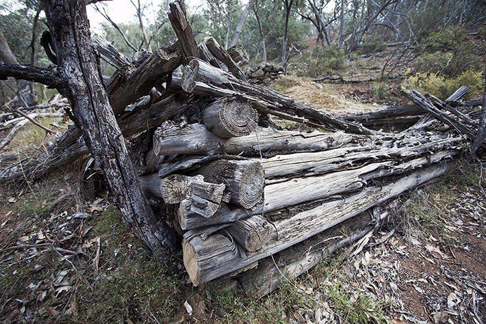
After lunch we rejoined the walking trail, which now headed away from the river following a small heavily eroded gully and passing a few more long-abandoned silver mines. The remains of an old pine log cabin gave us some idea as to the hardships that these miners must have faced. The walking trail soon started climbing again and took us through stands of tall cypress pine via a long series of switchbacks. The unusual pine forest was reminiscent of walking through the valleys in Nepal. On top of the spur we made a short detour to the lookout. Here we could see the glittering Snowy River as it twisted and turned along the wide sandy flats. Today the river is but a shadow of its former self and I couldn’t help wondering what it must have looked like before we tore its heart out and redirected its once mighty flow into the Murray River, all in the name of progress.
The last section of the walk continues through more cypress pine forest and eventually we rejoined Derrick Trail at where we passed earlier in the day. We got back to the car at about 5pm.

The Silver Mine Walking Track is 16.8km, not 18km as the official signs indicate, nor 15.5km as the free park notes indicate. The walk takes about 5 hours but allow 6 hours to include lunch.
I’ve described the walk in detail in our recent Daywalks Around Victoria walking guide ($22.95), which is available from the Open Spaces online bookstore or from outdoor adventure stores and book shops.
You should also check out Parks Victoria Snowy River National Park page and download their Silver Mine Walking Track PDF.

NOTE:
The McKillops Day Visitor Centre is closed from 23 May to 15 June 2012 due to a goat control program. This almost certainly means that the walk will be closed also. McKillops Bridge is also closed for repair works until 22 June from 8am to 4pm. Check with Parks Victoria on 13 1963 for details.
It’s a beautiful area. We made the mistake recently of attempting the Deddick Trail on mountain bikes. It’s insanely steep, so our planned 40km or so on the first day became 15km – most of that pushing. The descent (chainless – small mishap) was great though. (http://www.flickr.com/photos/felixdance/6302180466)
Interesting that you found the drive down to McKillop’s Bridge so dangerous – the road seemed pretty good to me? Asbolutely beautiful in any case (http://www.flickr.com/photos/felixdance/6301643157/)
Hi Steve. Yup, magic area indeed. Would love to see the river in full flood, not that it floods all that much these days. As for the road, lets just say I’m a bit of a wuss when it comes to narrow mountain roads. Too many Indian bus epics I reckon.
Hi Glenn, Nice area hey?! You should try being a passenger in a bus when we take rafting trips down there! At least unlike trips I haven been on in India and Nepal there are no burnt out wrecks down in the valley of previous ill fated expeditions. There was one semi driver a few years ago avoiding some road closures who followed his GPS directions to go via McKillopps- that didn’t go so well. Some other great walks in the area are from Little river falls downstream to the Devil’s backbone ridge and up to the Little river gorge lookout, or down the Devil’s backbone and through to where Little river meets the Snowy (or do the whole lot as a through walk). Apparently Wild magazine years ago rated it as one of the top 10 walks in Australia. There is a bit of abseiling, loose rock, and swimming involved though (depending on water levels). Needless to say it is quite adventurous. I have run a couple field trips for Charles Sturt University down there and we have some great photos. Another little known gem in the area is the paddle down the Buchan river from Greenhills track to Buchan township. Jack Hodge paddled it years ago and kept it very quiet. I paddled it about 20years later and have let a handful of people know now. At 1.9m it is an awesome long day of constant grade 3 (with a few bigger rapids thrown in) paddling in a beautiful location few people have been to. If you are keen for a raft down the river (or accommodation north of Buchan) check out Karoonda Park at Gelantipy.
Cheers,
Jayd
Hey Jayd, I’m really keen on one day doing a walk from Native Dog Flat and following the Buchan River all the way down. It looks like it could be a pretty wild trip. I’ve got to check out Google Earth and my 1:25s but I figure it will take about 7 days to walk and float(?). There is so much good country to explore through that region.
Thanks for the great report Glen. Dad and I did the walk in 2010 and got ourselves a bit lost on the last section of the track – see below for my account…
Keen to get on our way, we rose early, packed the car and were off and racing bound for the fabled McKillop Bridge. Three hours of windy snowy mountains rd and one kangaroo road kill later, we caught our first glimpse of the massive bridge. Not such an outstanding structure if you were driving through inner city Melbourne, but in the absolute wilderness of the Snowy River National Park, it was a magnificent spectacle. At 256m long and at an elevation of 191m the wooden trestle was built to provide a much needed means of crossing the mighty Snowy River in the early 1900’s when the area was being used for mining and farming. The current bridge is the 2nd edition – the original being heartbreakingly washed away by the Snowy’s largest flood, only days prior to its opening.
Having sighted and investigated the namesake of the region, we were keen to begin our hike, recommended as an overnight walk in the park notes, but being attempted by us in one day. The Silver Mine Walking track was an 18km walk that climbed up over the mountains for views back down on the river, descending past former silver mining sites and finishing with a trek back to the mighty bridge following the water course.
As we prepared to depart for the walk we discovered a slight oversight – we’d neglected to bring our primary water source, a 2 litre bladder of liquid. Fortunately we had full bottles in its stead and set off without further ado. We started climbing almost immediately along a rough four wheel drive track up a consistent incline – happy that the day was overcast and relatively cool. We walked past almost deafening pockets of large cicada populations, chirping incessantly to each other – unlike the green ones we’re accustomed to, these were black with almost devil-like eyes.
Within an hour, we’d reached a pinnacle that the notes described as some of the best views in the park and we weren’t disappointed. The outlook was vast and spectacular, with the ever-present snowy cutting an unerring path through the valley below. We continued to follow the four wheel drive trail, only coming across 2 vehicles on our way. A police 4 wheel drive, seemingly keeping an eye on walkers like ourselves with the potential of getting lost and a couple in a ute on a w/e drive. I was surprised to see that many cars because this place sure was remote. Eventually we came to a T intersection with the silver mine walking trail and turned right, heading back down towards the river. As we descended we began to spot signs of the silver mining that the area was used for in the early 1900’s. Significant tunnels, dark and foreboding, headed into the mountainside – we didn’t envy the miners who had been down them. We stopped for lunch shy of reaching the river because our energy levels were dwindling and needed to refuel our bodies. Back on the trail again after a balanced lunch, we came across the river and began following it back towards the bridge. This brought us to the overnight camping area which the notes recommended that we stop at for the night. Having not brought our camping gear and with a light drizzle starting to fall, it was onwards for us – no rest until we were back at the bridge. Rather than following the river all the way back to the bridge, the track climbed again to a steep ridge that afforded the best views of the day. Looking almost immediately downwards onto the river and the valley below we spent quite a time taking in the outlook and exploring the ridge.
Having soaked up the amazing vistas, we proceeded downwards again for the final leg of the walk. Not long into the final stage, the track that we were following completed petered out into dense shrubs. Being so remote, the track is clearly not used often – we didn’t see a single other walker all day. Not knowing where we’d gone wrong, we back-tracked for a while in an attempt to find the correct path. Unfortunately we couldn’t find an alternative route that looked more like the track, so we set back the way we’d came and again hit the dead end. With nothing else for it, and being able to see the bridge in the distance we continued along the river despite not having a track to follow. The going was slow and tough as we followed animal trails and tried to find the easiest path through the dense undergrowth. Adrenaline kicked in as we pushed on, slightly miffed that the walk had taken such as turn – having wanted to enjoy a relaxing stroll along the track to finish our trek. Eventually and inevitably Spence Snr stumbled upon the track and we finished off the walk taking some great pics of the bridge from below. The scenery and the hike were thoroughly enjoyable and were only slightly dampened by the difficulty in following the specified track. Content with our day’s efforts, the night was filled with setting up camp in a quiet campsite, enjoying a cooked meal and conversing around the camp fire about the day that had been.