Masons Falls Walk. Mt Sugarloaf is now open to the public. This includes Mt Sugarloaf, Mt Sugarloaf Road, Mt Sugarloaf Ridge Track and the park entrance area. These areas open everyday from 9:00am until 4:00pm. The walking trail (Mason Falls Circuit) and the rest of the Sugarloaf Block are still closed. Masons Falls Picnic Area… Continue reading Walks 56, 57 (Masons Falls and Andrew Hill)
Author: Open Spaces
Information, updates and news items are supplied by Open Spaces administration and may be sourced via our staff, authors, clubs and various land managers such as Parks Victoria.
Pioneers of Adventure
The current issue (March/April 2010) of Australian Geographic Outdoor has an article on Australian Pioneers. One of those pioneers featured was our very own Glenn Tempest. Australian photojournalist James McCormack (http://actiongoat.com) interviewed him here at our Melbourne office late last spring. In the interview Glenn recounts his first ascent of Kachoong at Mt Arapiles with… Continue reading Pioneers of Adventure
Arapiles Selected Climbs Corrections (2008 Edition)
These corrections have been listed by page number. They have been provided mainly by Simon Mentz and Glenn Tempest as well as various other users of the guide. If you have any corrections that you believe are relevant please send them to us at admin@osp.com.au. Please note that these corrections have been taken care of… Continue reading Arapiles Selected Climbs Corrections (2008 Edition)
Fire damage affecting information in several guidebooks
The terrible Victorian bushfires that started over the weekend of Sat 7th and Sun 8th February mean that some walks described in Daywalks Around Melbourne (Tempest), Weekend Walks Around Melbourne (Tempest) and Day Walks Melbourne (Chapman) have been completely destroyed. The main areas affected include Marysville, Kinglake, Murrindindi, Bunyip State Park, Healesville, Warburton and the… Continue reading Fire damage affecting information in several guidebooks
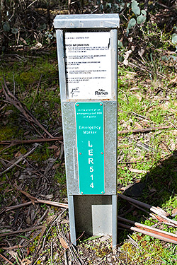
Lerderderg Gorge Emergency Markers
IMPORTANT UPDATE: All of the original EMERGENCY SIGNPOSTS in the gorge have been replaced with new EMERGENCY MARKERS by ESTA (Emergency Services and Telecommunications Authority). Of major concern, however, is that the original numbering has been changed. The old (original) numbering is still in use in a number of available publications, including two of our… Continue reading Lerderderg Gorge Emergency Markers
Cathedral Range Circuit (p110)
Roughly 92% of the Cathedral Range State Park (including the visitor facilities at Sugarloaf Saddle) were burnt by the February 2009 Black Saturday bushfires. All the roads and walking trails in the park are now closed. Parks Victoria have indicated that the park will be progressively reopened from December 2009.
Walk into History (p102)
Some sections (between Starling Gap and Ada No2 Mill Site, and along the Latrobe River) have had their signs removed or vandalised. The trail is also quite overgrown in places. In wet weather leeches are a real problem. I reckon the trail needs some serious maintenance and new signage before it disappears into the bush… Continue reading Walk into History (p102)
Lerderderg Gorge Walk (p80)
This walk has changed very little over the last few years. Unfortunately, the continuing dry conditions has reduced even the largest pools of water to little more than puddles. There is still plenty of water available (much of the river now trickles under the pebbles) but do remember to take a filter kit. In the… Continue reading Lerderderg Gorge Walk (p80)
Lerderderg Track (p68)
The Great Dividing Trail is closed (due to the February 2009 bushfires) south of Daylesford between Jubilee Hill and Leonards Hill Road. This is currently effecting about 8km of the trail. Note: There is a bus service running on a 12 month trial between Blackwood and Bacchus Marsh on Fridays. The bus leaves Bacchus Marsh… Continue reading Lerderderg Track (p68)
Dry Diggings Track (p50)
Golden Spring is closed for renovation.

