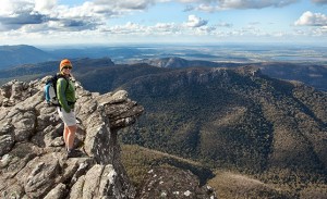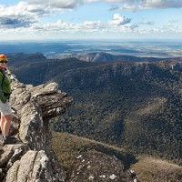
Karen and I drove up to Mt Rosea in the Grampians National Park last weekend to complete one of our walking circuits for the forthcoming Daywalks Around Victoria guidebook. This very scenic loop passes along the southern end of the Wonderland Range via Sundial Peak and culminates in an ascent of Mt Rosea, one of only a handful of mountains within the park that rises to over 1000 metres. Sundial Peak offers thrilling views overlooking Lake Bellfield and Halls Gap while Mt Rosea’s commanding position above the surrounding valleys guarantees one of the most expansive landscape vistas in Victoria.
The storms which blew across the Grampians a few weeks ago had ripped out large numbers of trees and the walking trail to the top of Sundial Peak was a real pain to negotiate. We spent almost an hour climbing over and between fallen timber before we reached the top. Once we left the summit the walking got a lot easier and we descended into the Silverband Valley to start our long climb up the Burma Track. We finally reached the summit of Mt Rosea by about 2pm. It was later than we had hoped and there was a bitterly cold breeze across the tops. The walk down to Rosea Carpark was great, especially in the late afternoon sunshine. Parks Victoria re-routed this walking trail a few years back and it now traverses some pretty spectacular semi-alpine ridges and open tops. We reached Rosea Carpark at 3.30pm and walked up the final steep hill back to Sundial Carpark. A really good day. As soon as the book goes to print we will place the GPS route on our Downloads page.
Distance: 16.3km, 6 hours
Grade: Difficult
Start/End: Sundial Carpark


i walked the mt rosea track last week and a section has been realigned after the jan 2011 floods. after the walk along the bush track section from the carpark it swings up the rocks but instead of passing thru the rocks into the next valley it now follows straight along up the ridgeline more.