Following the Black Saturday bushfires in 2009 pretty much all of the walking trail infrastructure in and around Marysville had been wiped out. I was in no doubt that repairs, rebuilding and realignments of this trail network would be at least a few years away. These fires meant that users of our Daywalks Around Melbourne book no longer had access to the seven described walks (walk 61, 62, 63, & 64 in the Marysville and Lady Talbot Drive area as well as walks 65, 66 and 67 in the nearby Lake Mountain and Cambarville area).
Last week I spent a couple of days in Marysville with Parks Victoria and the Department of Sustainability and Environment (DSE). I was fortunate to have been shown around the new trail infrastructure by Simon Gough, the Bushfire Recovery Project Co-ordinator for DSE in Marysville, and by Mark Krause, the Assistant Ranger in Charge for the Yarra Ranges National Park. It was a fascinating and very informative tour and I learned a lot about the difficulty in repairing, designing and building walking and cycling trails. DSE and Parks Victoria have done an enormous amount of work since the fires and the good news is that most of the trails are now open. Those that aren’t are perhaps only a couple of months away. Bushwalking always been a major attraction for visitors to Marysville and the reopening of these trails will be seen as an important step towards recovery.
Here is a listing of the walking trails in Daywalks Around Melbourne and their current status.
Walk 61 (Island Hop & Red Hill) The new walk is called the Michaeldene Trail and is a circuit following some of the original historic tramlines. The major attraction is a wooden platform overlooking the rushing Taggerty River. The circuit walk is currently closed but will hopefully be open before winter.
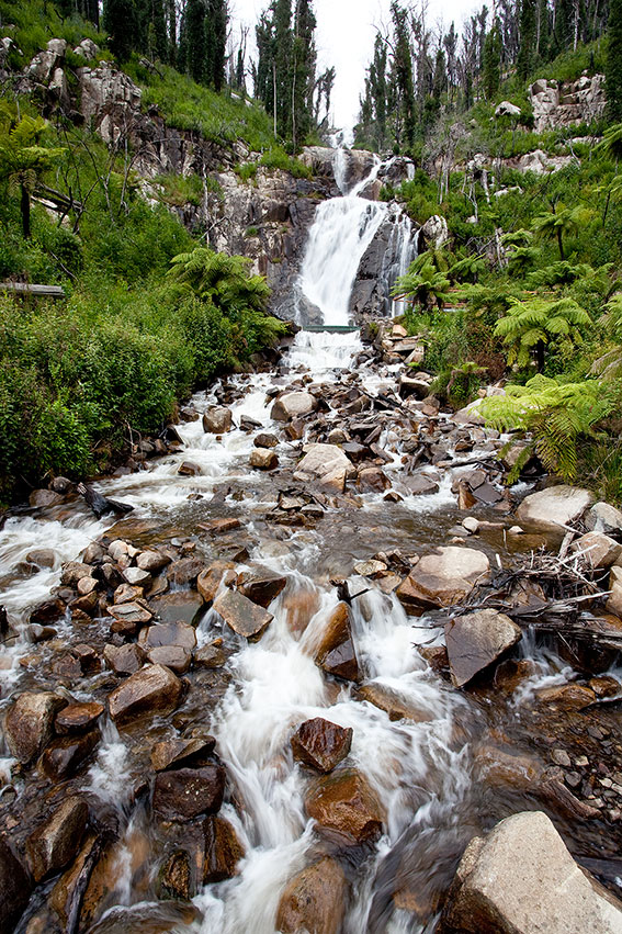
Walk 62 (Keppel Lookout & Stevenson Falls) Now called the Steavenson Falls Trail there has been some major realignments (especially above Steavenson Falls). The trail will be open in the coming spring and I have no doubt that it will be an even better walk than it was in the past.
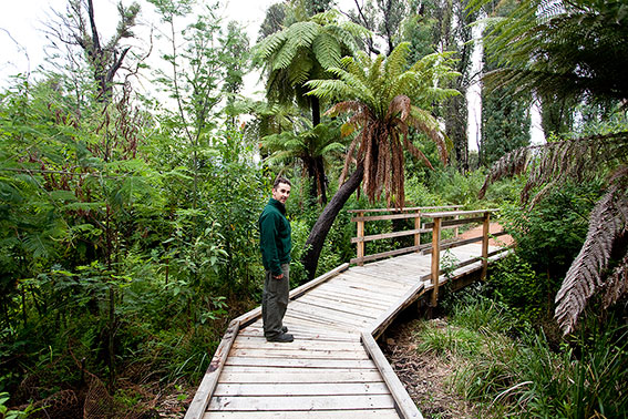
Other trails in Marysville that are nearing completion (but which are not described in Daywalks Around Melbourne) include the Beauty Spot Trail (all new timber boardwalks and bridges), Tree Fern Gully Trail (wide compacted gravel surface for walkers and cyclists), Gilberts Gully Trail (new boardwalks and steel bridges) and Wilks Creek Trail (wide multi-use trail out to Anderson Mill site).


Walk 63 (The Beeches) Lady Talbot Drive is open as are the two short walks up to Phantom and Keppel Falls. The Beeches Rainforest Walk has also seen a lot of work including the installation of floating boardwalks. This 4km circuit is open except for the timber bridge spanning the Taggerty River. The walk down to the cascades from the first carpark (Taggerty River Crossing) is called Taggerty River Cascades and has had new steps installed down along the river.

Walk 64 (Boundary Trail) This walk as described in Daywalks Around Melbourne is closed. Boundary Trail West is probably full of regrowth now and may not be easy to locate. However, Keppel Hut has been rebuilt and Boundary Trail East is open to the summit of Lake Mountain. I haven’t walked this section yet, but when I do I will post an update.
Walk 65 & 66 (Lake Mountain) All of the walks and mountain bike trails are open.
Walk 67 (Cumberland Walk) This is now called Cumberland Falls Walk and is open. The 2009 fires thankfully missed much the area around the Big Tree. Parks Victoria have installed a clinometer near the Big Tree which is used to measure the height of the surrounding mountain ashes. This can be used free of charge by the public. There are great views into the Cumberland Valley from the southern part of the walk. Parks Victoria have also opened another short circuit walk in the historic township of Cambarville. This easy loop passes the old Chalet Hubertus, school and sawmill sites. There are interpretation signs along the way.

Hi Glenn,
Great news! Marysville and surrounds was one of my favourite places for short walks before the fires.
Just wanted to clarify about the Beeches Rainforest Walk, will the bridge be completed in coming months too or can the circuit be completed without the bridge?
Thanks
Neil
The Beeches Rainforest Walk can’t be completed as a circuit right now but I think Parks Victoria intend to repair the bridge within a month or so. I understood it will be ready before winter.
Wow! Looks like the place has sprung back to life.
I cant wait to head out there when Stevenson falls is back open, Looks pretty incredible. The new infrastructure looks good too.
Thanks for clarifying Glenn. I can’t wait to get out there either. Haven’t been since a few months before the fires.
This is not (obviously) about Marysville walks, but about the Upper Yarra Goldfields walk (Walk 83) which we did on the weekend (11 April). Although I had taken the precaution of checking the DSE and Parks Vic websites re changed conditions and closures, this area wasn’t mentioned. However, on the gate across Peninsula Rd, near the big Peninsula Tunnel, was a sign stating the road was closed to traffic due to danger from falling limbs. There was a detached, upside sign which we saw on the way out, that said the Goldfields walk was closed. As you can tell, we did it anyway, walking up the easement initially. From 4.4 km to 6.5 km, along the water race, there was a lot of clambering over fallen tree trunks and we almost lost the track a couple of times, because it has become so overgrown. But very beautiful forest, with huge mountain ash, and very tall tree ferns, plus several lyrebirds in the distance. It seems the track is officially closed because it hasn’t been maintained – but it wasn’t dangerous, and was well worth doing.
My parents and I do these walks regularly. They are very good for Melbourne people. I get around in a 4X4 wheelchair which my brother bought in 2008. I recommend people with disabilities do try to go wheeling in such a beautiful place. This is worth getting out of your Melbourne wheelchair because it is a lot of fun. Jason
Contact me on 0359633413
Hello,
Re walk 83. ( Upper Yarra Goldfields walk).
While i was working at the now long gone Box Hill Tafes Camp Reefton i discovered the mining heritage of this area and subsequently applied for a Bi Centennial grant to clear and develop it.( and then frequently keep it clear with help from other staff there)
During my many years at this camp i would have ( as a camp activity instructor) taken many thousands of school students over this walk.
They really enjoyed the glow worms in the mine tunnel.
After the ash wed fires i discovered the extent of the old workings and was amazed at the work the miners would have done.
The water race on this part of the track actually seemed to go right over to the o shanasy river as its source and right back as far as beyond Reefton where it apparently powered a water wheel operated crusher (years ago )near where “Minifies” re opened the mines.
There is also a water race from the Lake Mountain area which sort of follows down the Reefton spur road ( this goes right past the mt morgan mine in that area.
The fact that the road is closed is a crock to reduce maintenance etc. There never was a falling tree branch problem but near the camp reefton site there was a falling rock problem,
Cheers
Robert
Can anyone tell me what impact the fires had on the Beeches area on Taggerty Rvr, Marysville.
I am hoping that not all those magnificent Nothofagus (Beech) are burnt……!
Pete
Hi Peter. You’ll be pleased to learn that the Beeches on Lady Talbot Drive (along Whitehouse Creek and along the Taggerty River) survived the fires. Some small sections were burnt but they came through suprisingly well.
Hello Glen I came across your name when I did a google search for the reefton school camp. I was sorry to see it no longer there when I walked to it a couple of years ago. I use to go there when I went to Box Hill Tech. Can you tell when and why it closed. I would be most interested. Thank You. Paul
Hi Paul. Sorry but I have no information about the Reefton School Camp. Hopefully Robert (above) will help you out. I wouldn’t be surprised if the place had fallen victim to fire but I would only be guessing.
Hello Robert can you tell me why the Reefton School Camp was closed as I use to go there when I went to Box Hill Tech. I went to see it on a walk but when I got to the spot it had gone. I had the right spot as I remember a large gum tree on the left hand side of the bend on the road just before you entered the camp. Thank You
Hello Paul.
I actually came to Camp Reefton in its infancy straight from the army. The first year there ( about 1972) i was part time at the camp and part time student at the tec.
There were many improvements as time went on including the building of the rec hall and the brown house that Mike lived in for awhile.
I initiated many of the activities including abseiling/ rock climbing, bush walking and canoeing that were later expanded on when extra staff were employed.
All up i was employed there for about 19 years ( I was the one with the short wheel base green Land Rover) and while i knew of various mining activities from the past in the area i had not connected the dots.
During the Ash Wed bush fires the camp was vacant and i was heavily involved with Vic SES at Wesburn ( as communiications officer).
The camp was surrounded by fire but was untouched. After the fires it was closed for a time and i prowled the now black and bare hills and saw the extent of the old gold workings.
Subsequently i applied for a bi centennial grant to develop some of it and produce a map. Then over the many following years we took thousands of kids for a day walk over it.Possibly even yourself
Subsequently in about Feb 1991 i was retrenched and the camp “privatized”under the direction of the then manager. I was the only remaining original staff member.
This manager then employed various casual outdoor workers etc but i suspect it then went on a downwards spiral.
Some years ago i revisited the camp and found it abandoned with various bits and pieces removed ( such as roofing iron) although all the buildings( and some gear, including stuff still hanging where i had left them) were there.
I was able to read the camp visitors book that was still in the mess hall and it was very apparent to me the camp was not providing as it had.
The office was open and the contents of the filing cabinets strewn about. As a memento i was able to retrieve the T shirt printing screen printing master, “I kayaked it at Reefton”
While there I was sprung by the arrival of a govt officer from dept of sport and recreation who turned up to assess if the camp, even at that stage, could be resurrected
Apparently it couldn’t or wouldst be..as i later heard the entire camp was auctioned off and carted away by trucks
Not long ago i google earthed the site and its just a shrinking green patch in the bush. As i knew where to look i could still see the foundation outlines from the various buildings
My gut feeling as to why the camp closed is that it didnt really “fit” with a TAFE college as we mainly had primary age students. This along with privatising that greatly reduced the services provided. By this stage Mike had left and there was another manager
For me, now , even writing this, there are many happy memories and the local sayings of ” once in the Yarra Valley, always in the Yarra Valley” seem to ring true as the valley has and retains a “pull” on me.
I now live in Queensland, near Brisbane but in a rural setting. ( in fact to get this computer going i first had to remove various circuit boards to get a snake that had been fried
Hope this is of interest
cheers
Robert
Hello Robert thanks for the information. The last time I was at the camp when it was still going I and one or two other students cant remember stayed in a caravan that was there for a night I can not remember why. I remember the rec. hall that was the metal clad building down on the lower part of the camp close to the river.Are you able to tell me where I could get a copy of the map you produced. Also one time I and two mates both of whom went to the camp drove in to see the camp it was still there and it looked like it was still open.
I went to the old camp very recently. The bush has pretty much claimed it back now and the old mine entrance has given way.
Believe it or not the whole of Peninsula Rd is now closed to vehicle access.
I found the start of the track to the old rock climbing wall but sadly even that is now un-traceable.
I’m still trying to work out if I had you at the camp Robert as I would have attended about 1990/91.
Oh and finally … Robert, did you keep that map ?
Hi Glenn, do you have a more recent status of the Boundary Trail? I was at the Marysville Info Centre a few weeks ago, and it appears we can access the start of the walking trail, but via Mount Margaret Road.
Cheers.
Hi Greg. I don’t have any further details of the Boundary Trail but was under the impression that sections of it had vanished under regrowth. I won’t be up that way any time soon so I would be interested if anyone has any up to date information.
Any idea where I can get a copy of your book ‘Daywalks around Melbourne’? Everywhere says out of print. Any chance of getting a Kindle version uploaded to the Amazon store?
Sorry Duncan, but Daywalks Around Melbourne is currently out of print. I’m considering releasing it as a PDF e-book but it won’t be until later in the year.
I was chatting with hubby reminiscing over fond childhood memories and on the topic of school camps I jumped on here to search for my favorite camp “camp reefton” with which I attended for a wk in grade 4 back in 1995 now lol Having said that I’m glad I read this post and also very sad to hear of what came of it!
I remember abseiling, canoeing, some obstacle course where admittedly we came out reeking lol, bush walking including night walks, camp fires, activities in the hall…. ooh and leeches…lotsa leeches lmao
Very sad to hear it didn’t last on or others 🙁
Hello Robert, I attended camp reefton in 1971 and 1972 in forms 1 and 2 but not sure about 3 etc. while at Box Hill Tech. I too have great memories of it. My father and eldest brother helped build the place. I remember sleeping in the portables with bunk beds. One time I went up to the hall at night after dinner and we helped ourselves to a milo. Yes, canoing, orienteering in the wet., one legged races. I have some old happy snaps somewhere. I too ended up in Bemont, Brisbane. My last name is Kirkup. I had a couple of brothers at Box Hill Tech. Very fond memories indeed.
Cheers
James
Hello all, I having been trying to find the original coordinates for the old camp reefton as I have forgotten where it was. If anyone in the future comes across this pist and knows the coordinates so I can google earth it that would be appreciated.
Hello James.
Out of curiosity today i google earthed the Camp Reefton site. While i did zoom in etc and saved a couple of images ( closer up and more distant) it seems this site has no provision for me to include them. ( dont know how to get co ordinates etc)
However if you google earth and fly up the road from warburton/ East Warburton to Mc mahons creek and a bit furthur along there are cleared areas to the north of the road.
Right at the northern most area of the clear farm land there is a smallish clear spot separated by trees and a closer zoom in reveals former building foundations. Notably some straight lines ( prob dining hall) and down the bottom far left of this small area there is a circle ( prob former sewage treatment area)
I also have the gold mine walking track —- map and track notes but unfortunately this site seems to have no provision for posting it
I spent nearly 20 years working at camp reefton
cheers
Robert