Posted on Leave a comment

Bears Head Circuit – Lerderderg Gorge SP

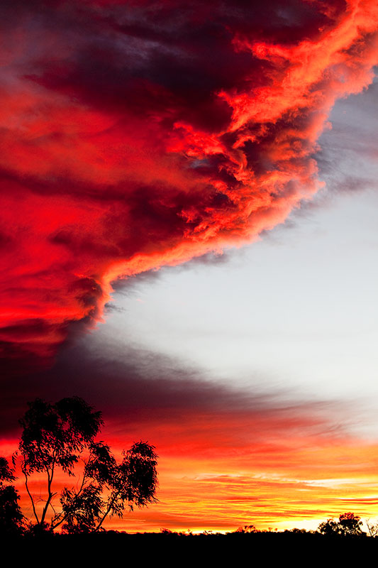
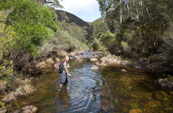
It’s hard to believe that so close to Melbourne exists such a gem of a park. The Lerderderg State Park offers a plethora of walk choices. We chose the Bears Head Circuit, a 15+k walk that keeps you interested from start to end. As all great walk stories must include, the weather was perfect. Starting off on what looked a little like the small village roads you see in the UK, we were surprised and pleased, to see an old Red Rattler on one of the side properties. Although in a state of disrepair, it didn’t fail to ignite the wanderings down memory lane. After about 10 minutes of childhood memories, we were eager to continue on and headed into the bushland proper. From the steep descent down the gorge, we were then greeted by a river which was far from a trickle. Our initial plans of walking up the river bed dry were abandoned. Rather than bush bash along some of the heavily vegetated banks we opted for walking up the river bed wet. What a great choice! The water was refreshing and allowed us to (carefully) traverse from one side to the other visiting the disused mining areas that were built along the banks. Dry stoneworked water races allowed us an even walking surface before once again heading off track for a bit of an explore or another dip of the toes, and legs, into the river. An exciting rock scramble up the Bears Head Ridge gave us amazing views of the park and beyond. Made all the more interesting by the fact that the the sense of remoteness we were experiencing was offset by the sight of Melbourne city not too far in the distance.

I had a brilliant day, it kept my interest up the whole time. Great little lunch and snack spots, history trips back in time and some very definite ideas about overnight camps.

bears_head_range
Wading down the Lerderderg River
Posted on 5 Comments

Lerderderg Gorge Emergency Markers

IMPORTANT UPDATE: All of the original EMERGENCY SIGNPOSTS in the gorge have been replaced with new EMERGENCY MARKERS by ESTA (Emergency Services and Telecommunications Authority). Of major concern, however, is that the original numbering has been changed. The old (original) numbering is still in use in a number of available publications, including two of our own books and in the very popular Lerderderg and Werribee Gorges Meridian map. Walkers using our guides and the Meridian map must not confuse the original numbering with the new numbering.

Please download the following PDF which spells out all of the changes and even includes the Emergency Markers GPS co-ordinates:

LERDERDERG STATE PARK EMERGENCY MARKERS

Posted on 2 Comments

Chewings Range Traverse

Karen and I recently spent 18 days and 250km walking across the Chewings Range in the Northern Territory. Two old friends, Stuart Imer and Michael Hampton, joined us for what turned out to be one of the best long distance walks we have ever done. We started out of Alice Springs and followed the first seven days of the Larapinta Trail to Hugh Gorge. The next nine days were spent off-trail, weaving our way among the incredible gorges and mountains that stretched across the Chewings. We rejoined the Larapinta Trail at Ormiston Gorge and walked the final couple of days along to our finish at Redbank Gorge. It was an amazing experience. There are no worthwhile maps to the more remote sections of the Chewings and so we relied heavily on our Garmin GPS. Only a few of the gorges are named and there is no information as to the whereabouts of reliable drinking water. Karen and I have managed to notch up a fair few kilometres over the years walking in the Western MacDonnell’s (which is where the Chewings Range resides) and have become quite good at searching out water in the most unlikely of places. Here is a valuable tip for anyone considering an off-trail walk in Central Australia. Watch out for finches. These delicate little birds don’t venture far from water and as soon as you spot one, you can be sure that water is very close by.

A southerly storm across the Chewings Range
Posted on 2 Comments

Werribee Gorge & The Island

I visited Werribee Gorge State Park on Wednesday. It turned out to be one of those perfect spring days that  Melbourne is justifiably famous for. My friend, Ian, had never been to ‘the gorge’ before and I took the opportunity to show him around what I consider to be one of the most underrated parks near to Melbourne. It was also a good excuse to check out the new W. James Whyte Island Reserve (known simply as The Island). A new trail links the top carpark to The Island via some wonderful yellow box woodland. There are excellent views across Junction Pool and the trail allows walkers to experience a refreshingly new aspect of the park . It’s a steep climb to the top of The Island. Actually, I’ll rephrase that. It’s a BLOODY steep climb to the top. This massive basalt hill is part of the lava flow which originated from Mt Bullangarook near Gisborne. The views overlooking the gorge are arguably the best in the district.

The 204 hectare W. James Whyte Island Reserve was gifted to Conservation Volunteers in August 2006. There has been an enormous amount of work planting native trees and shrubs,  as well as a concerted effort at controlling weeds. It really is an big task. If you are interested in donating a bit of your time to Conservation Volunteers in their revegetation of The Island, check out www.conservationvolunteers.com.au or contact 1800 032 501.

The Island, overlooking Junction Pool. Werribee Gorge State Park.
Posted on 2 Comments

Cathedral Range Circuit (p110)

Roughly 92% of the Cathedral Range State Park (including the visitor facilities at Sugarloaf Saddle) were burnt by the February 2009 Black Saturday bushfires. All the roads and walking trails in the park are now closed. Parks Victoria have indicated that the park will be progressively reopened from December 2009.

Posted on Leave a comment

Walk into History (p102)

Some sections (between Starling Gap and Ada No2 Mill Site, and along the Latrobe River) have had their signs removed or vandalised. The trail is also quite overgrown in places. In wet weather leeches are a real problem. I reckon the trail needs some serious maintenance and new signage before it disappears into the bush for good.

Posted on Leave a comment

Lerderderg Gorge Walk (p80)

This walk has changed very little over the last few years. Unfortunately, the continuing dry conditions has reduced even the largest pools of water to little more than puddles. There is still plenty of water available (much of the river now trickles under the pebbles) but do remember to take a filter kit. In the warmer months there are large numbers of red belly black snakes which seem to feed upon smaller prey, which are forced into using the small number of waterholes. The gorge has taken a real hammering over the course of the last ten dry years and many of the shade trees (the wattles) have either died or have lost most of their leaves. Large areas of blanket-leaves and hazel pomaderris have vanished. This spring (2009) the river has been occasionally flowing, which has been really wonderful.


IMPORTANT UPDATE (Spring 2009): All of the original EMERGENCY SIGNPOSTS in the gorge have been replaced with new EMERGENCY MARKERS by ESTA (Emergency Services and Telecommunications Authority). Of major concern, however, is that the original numbering has been changed. The old (original) numbering is in use in a number of available publications, including two of our own books and in the very popular Lerderderg and Werribee Gorges Meridian map. Walkers using our guides and the Meridian map must not confuse the original numbering with the new numbering. Please download the following PDF which spells out all the changes and even includes the Emergency Markers GPS coordinates: LERDERDERG STATE PARK EMERGENCY MARKERS

Posted on Leave a comment

Lerderderg Track (p68)

The Great Dividing Trail is closed (due to the February 2009 bushfires) south of Daylesford between Jubilee Hill and Leonards Hill Road. This is currently effecting about 8km of the trail. Note: There is a bus service running on a 12 month trial between Blackwood and Bacchus Marsh on Fridays. The bus leaves Bacchus Marsh at 2.15pm and arrives in blackwood at 2.50pm. It leaves Blackwood on Friday at 9.05am and gets to Bacchus March at 9.40am. You can connect to both the Melbourne and Ballarat trains.