

Following the Black Saturday bushfires in 2009 pretty much all of the walking trail infrastructure in and around Marysville had been wiped out. I was in no doubt that repairs, rebuilding and realignments of this trail network would be at least a few years away. These fires meant that users of our Daywalks Around Melbourne book no longer had access to the seven described walks (walk 61, 62, 63, & 64 in the Marysville and Lady Talbot Drive area as well as walks 65, 66 and 67 in the nearby Lake Mountain and Cambarville area).
Last week I spent a couple of days in Marysville with Parks Victoria and the Department of Sustainability and Environment (DSE). I was fortunate to have been shown around the new trail infrastructure by Simon Gough, the Bushfire Recovery Project Co-ordinator for DSE in Marysville, and by Mark Krause, the Assistant Ranger in Charge for the Yarra Ranges National Park. It was a fascinating and very informative tour and I learned a lot about the difficulty in repairing, designing and building walking and cycling trails. DSE and Parks Victoria have done an enormous amount of work since the fires and the good news is that most of the trails are now open. Those that aren’t are perhaps only a couple of months away. Bushwalking always been a major attraction for visitors to Marysville and the reopening of these trails will be seen as an important step towards recovery.
Here is a listing of the walking trails in Daywalks Around Melbourne and their current status.
Walk 61 (Island Hop & Red Hill) The new walk is called the Michaeldene Trail and is a circuit following some of the original historic tramlines. The major attraction is a wooden platform overlooking the rushing Taggerty River. The circuit walk is currently closed but will hopefully be open before winter.
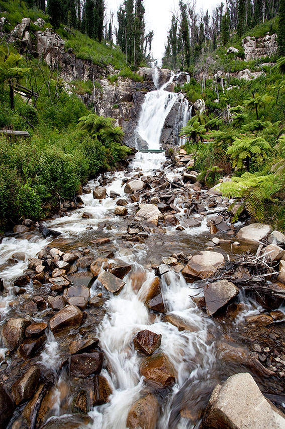
Walk 62 (Keppel Lookout & Stevenson Falls) Now called the Steavenson Falls Trail there has been some major realignments (especially above Steavenson Falls). The trail will be open in the coming spring and I have no doubt that it will be an even better walk than it was in the past.
Other trails in Marysville that are nearing completion (but which are not described in Daywalks Around Melbourne) include the Beauty Spot Trail (all new timber boardwalks and bridges), Tree Fern Gully Trail (wide compacted gravel surface for walkers and cyclists), Gilberts Gully Trail (new boardwalks and steel bridges) and Wilks Creek Trail (wide multi-use trail out to Anderson Mill site).


Walk 63 (The Beeches) Lady Talbot Drive is open as are the two short walks up to Phantom and Keppel Falls. The Beeches Rainforest Walk has also seen a lot of work including the installation of floating boardwalks. This 4km circuit is open except for the timber bridge spanning the Taggerty River. The walk down to the cascades from the first carpark (Taggerty River Crossing) is called Taggerty River Cascades and has had new steps installed down along the river.

Walk 64 (Boundary Trail) This walk as described in Daywalks Around Melbourne is closed. Boundary Trail West is probably full of regrowth now and may not be easy to locate. However, Keppel Hut has been rebuilt and Boundary Trail East is open to the summit of Lake Mountain. I haven’t walked this section yet, but when I do I will post an update.
Walk 65 & 66 (Lake Mountain) All of the walks and mountain bike trails are open.
Walk 67 (Cumberland Walk) This is now called Cumberland Falls Walk and is open. The 2009 fires thankfully missed much the area around the Big Tree. Parks Victoria have installed a clinometer near the Big Tree which is used to measure the height of the surrounding mountain ashes. This can be used free of charge by the public. There are great views into the Cumberland Valley from the southern part of the walk. Parks Victoria have also opened another short circuit walk in the historic township of Cambarville. This easy loop passes the old Chalet Hubertus, school and sawmill sites. There are interpretation signs along the way.